|
search place name
|
||
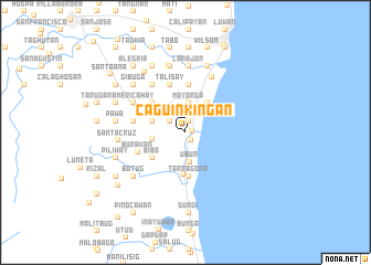
Caguinkingan (Leyte, Philippines)Caguinkingan is a town in the Leyte region of Philippines. An overview map of the region around Caguinkingan is displayed below.
regional and 3d topo map of Caguinkingan, Philippines ::
Caguinkingan airports ::
The nearest airport is TAC - Tacloban Daniel Z Romualdez, located 39.4 km north of Caguinkingan.
Other airports nearby include NOP - Masbate Mactan Cebu Intl (127.7 km south west), DGT - Dumaguete (252.1 km south west), Nearby towns ::
Liberty (0.6km east) //
San Pedro (1.0km south east) //
Gintuluyan (1.2km north) //
Union (1.9km north west) //
Gibuga (1.9km north west) //
Ubun (3.0km south) //
Mayorga (3.0km north) //
Caluslugan (3.4km west) //
Doyog (3.5km west) //
Bincay (3.7km north east) //
Bibo (4.2km south west) //
MacArthur (4.3km south) //
Tarragona (4.4km south) //
Pericuhon (4.5km north west) //
Gibuga (4.5km north west) //
Bungtod (4.5km north west) //
Ginbucaran (4.9km north) //
La Paz (5.0km north west) //
Talisay (5.1km north) //
Burakan (5.1km south west) //
Gimaranat (5.3km west) //
Moroboro (5.3km west) //
Qui-ong (5.3km west) //
Limba (5.3km west) //
Kapakunan (5.9km north west) //
Americahay (5.9km north west) //
Rizal (6.2km north east) //
Lanajon (6.7km north) //
Alegre (6.7km north) //
[all distances 'as the bird flies' and approximate]  Places with similar names to Caguinkingan, Philippines :: Disclaimer :: Information on this page comes without warranty of any kind |
||
|
Where is Caguinkingan? Elevation and coordinates ::
Latitude (lat): 10°52'23"N Longitude (lon): 124°59'49"E
Elevation (approx.): 12m (map arrows pan, magnifying glasses zoom) |
||
|
Visiting Caguinkingan? Hotel/Accommodation ::
Book a hotel in Caguinkingan Travel Guide ::
Buy a travel guide for Philippines rental cars ::
car rental offers GPS waypoint ::
download a GPX waypoint (PoI) of Caguinkingan for your GPS receiver
|
||