|
search place name
|
||
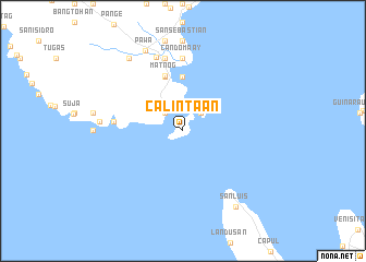
Calintaan (Sorsogon, Philippines)Calintaan is a town in the Sorsogon region of Philippines. An overview map of the region around Calintaan is displayed below.
regional and 3d topo map of Calintaan, Philippines ::
Calintaan airports ::
The nearest airport is TAC - Tacloban Daniel Z Romualdez, located 176.3 km south east of Calintaan.
Other airports nearby include KLO - Kalibo (210.1 km south west), BCD - Bacolod (245.0 km south west), ILO - Iloilo (263.2 km south west), Nearby towns ::
San Jose (2.6km north west) //
Lamaoan (2.6km north west) //
Subic (2.6km north east) //
Calasi (4.1km north west) //
Gurong Banua (5.6km north) //
Balocawe (5.8km north) //
Genablan (5.8km north) //
Matnog (5.9km north) //
Ginablan (7.0km west) //
Candomaay (7.4km north) //
Culasi (7.6km north) //
Manjumlad (7.6km north) //
Calibag (8.0km north) //
Mambajog (8.4km west) //
Pawa (9.1km north west) //
Mansibog (9.2km north west) //
San Luis (9.4km south east) //
[all distances 'as the bird flies' and approximate]  Places with similar names to Calintaan, Philippines ::
// Cline Town (SL)
// Calanutan (PH)
// Calinta-an (PH)
// Calintaan (PH)
// Calintaan (PH)
// Calunetan (PH)
// Kaliantana (PH)
// Clanton (US)
// Clinton (US)
// Kleinotten (AT)
Disclaimer :: Information on this page comes without warranty of any kind |
||
|
Where is Calintaan? Elevation and coordinates ::
Latitude (lat): 12°32'0"N Longitude (lon): 124°6'0"E
Elevation (approx.): 34m (map arrows pan, magnifying glasses zoom) |
||
|
Visiting Calintaan? Hotel/Accommodation ::
Book a hotel in Calintaan Travel Guide ::
Buy a travel guide for Philippines rental cars ::
car rental offers GPS waypoint ::
download a GPX waypoint (PoI) of Calintaan for your GPS receiver
|
||