|
search place name
|
||
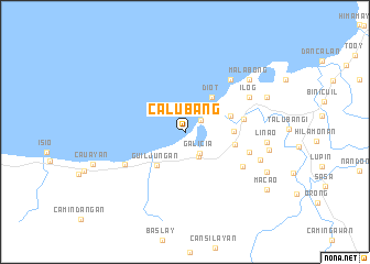
Calubang (Philippines)Calubang is a town in Philippines. An overview map of the region around Calubang is displayed below.
regional and 3d topo map of Calubang, Philippines ::
Calubang airports ::
The nearest airport is BCD - Bacolod, located 74.9 km north of Calubang.
Other airports nearby include ILO - Iloilo (80.7 km north), DGT - Dumaguete (98.4 km south east), SJI - San Jose Antique (119.8 km north west), NOP - Masbate Mactan Cebu Intl (143.3 km east), Nearby towns ::
Bocana (1.9km north east) //
Galicia (2.5km south east) //
Dancalan (2.8km south east) //
Guiljuñgan (4.3km south west) //
Diot (4.4km north east) //
Paz Hacienda (4.8km east) //
Consuelo (4.8km east) //
Vista Alegre (5.0km east) //
Manalad (6.0km east) //
Libas (6.6km south east) //
Tolong (6.6km east) //
Tiling (6.8km south west) //
Diut (7.0km north east) //
Ilog (7.2km north east) //
San Agustin Hacienda (7.2km north east) //
Delicioso (7.9km east) //
Linao (8.2km east) //
Malabong (8.3km north east) //
Camugao (8.5km east) //
Andulawan (8.9km north east) //
Salong (9.0km south east) //
Macao (10.0km south east) //
[all distances 'as the bird flies' and approximate]  Places with similar names to Calubang, Philippines ::
Disclaimer :: Information on this page comes without warranty of any kind |
||
|
Where is Calubang? Elevation and coordinates ::
Latitude (lat): 10°0'6"N Longitude (lon): 122°42'32"E
Elevation (approx.): 11m (map arrows pan, magnifying glasses zoom) |
||
|
Visiting Calubang? Hotel/Accommodation ::
Book a hotel in Calubang Travel Guide ::
Buy a travel guide for Philippines rental cars ::
car rental offers GPS waypoint ::
download a GPX waypoint (PoI) of Calubang for your GPS receiver
|
||