|
search place name
|
||
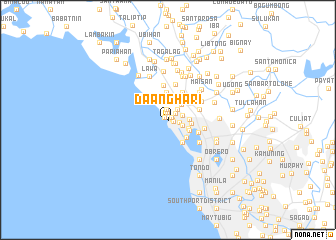
Daanghari (Caloocan, Philippines)Daanghari is a town in the Caloocan region of Philippines. An overview map of the region around Daanghari is displayed below.
regional and 3d topo map of Daanghari, Philippines ::
Daanghari airports ::
The nearest airport is MNL - Manila Ninoy Aquino Intl, located 20.3 km south east of Daanghari.
Other airports nearby include BAG - Baguio (191.4 km north), Nearby towns ::
Tañgos (0.4km north west) //
Tanza (0.5km north east) //
Malabon (0.5km east) //
San Roque (0.6km east) //
Gasak (0.8km north) //
Bayanbayanan (1.1km north east) //
Almacen (1.2km north) //
Concepcion (1.3km east) //
Dampalit (1.6km north east) //
Mozon (1.6km east) //
San Antonio (1.7km east) //
Maasim (1.7km east) //
Navotas (1.7km east) //
Pangjulo (2.3km north east) //
Tenejeros (2.3km east) //
Niugan (2.4km east) //
Tonsuya (2.6km south east) //
Catmon (2.6km east) //
Navotas (2.8km south east) //
San Agustin (3.0km south east) //
Bangculasi (3.0km south east) //
Julong Flores (3.0km south east) //
Bagumbayan (3.0km south east) //
San Jose (3.0km south east) //
Julong Duhat (3.0km south east) //
Santulan (3.0km south east) //
Ibaba (3.0km south east) //
Longos (3.0km south east) //
Baritan (3.0km south east) //
[all distances 'as the bird flies' and approximate] 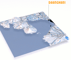 Places with similar names to Daanghari, Philippines ::
Disclaimer :: Information on this page comes without warranty of any kind |
||
|
Where is Daanghari? Elevation and coordinates ::
Latitude (lat): 14°40'21"N Longitude (lon): 120°56'6"E
Elevation (approx.): 7m (map arrows pan, magnifying glasses zoom) |
||
|
Visiting Daanghari? Hotel/Accommodation ::
Book a hotel in Daanghari Travel Guide ::
Buy a travel guide for Philippines rental cars ::
car rental offers GPS waypoint ::
download a GPX waypoint (PoI) of Daanghari for your GPS receiver
|
||