|
search place name
|
||
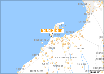
Dalahican (Cavite, Philippines)Dalahican is a town in the Cavite region of Philippines. An overview map of the region around Dalahican is displayed below.
regional and 3d topo map of Dalahican, Philippines ::
Dalahican airports ::
The nearest airport is MNL - Manila Ninoy Aquino Intl, located 16.1 km north east of Dalahican.
Other airports nearby include BAG - Baguio (214.8 km north), Nearby towns ::
Santa Sevilla (0.2km south east) //
San Rafael (1.3km south) //
San Juan (1.8km south east) //
Wakas (1.9km east) //
Putol (1.9km south) //
San Jose (2.0km south) //
Santa Isabel (1.9km east) //
Panamitan (1.9km east) //
San Sebastian (1.9km east) //
Kaiñgin (1.9km east) //
Tabon (1.9km east) //
Noveleta (2.1km south) //
San Antonio (2.5km south) //
Kawit (2.5km east) //
Santa Rosa (2.8km south) //
Lamitan (2.8km south east) //
Ligtong (2.9km south west) //
Caridad (3.2km north) //
Marulas (3.5km east) //
Toclong Segundo (3.5km east) //
Medicion (3.6km east) //
San Antonio (3.7km north) //
Banalo (3.7km east) //
San Roque (3.8km north east) //
Gahak (3.8km east) //
Paso de Tabla (4.0km south west) //
Muzon (4.0km south west) //
Cañacao (4.3km north) //
Alapan Segundo (4.4km south east) //
[all distances 'as the bird flies' and approximate]  Places with similar names to Dalahican, Philippines ::
Disclaimer :: Information on this page comes without warranty of any kind |
||
|
Where is Dalahican? Elevation and coordinates ::
Latitude (lat): 14°27'4"N Longitude (lon): 120°52'56"E
Elevation (approx.): 8m (map arrows pan, magnifying glasses zoom) |
||
|
Visiting Dalahican? Hotel/Accommodation ::
Book a hotel in Dalahican Travel Guide ::
Buy a travel guide for Philippines rental cars ::
car rental offers GPS waypoint ::
download a GPX waypoint (PoI) of Dalahican for your GPS receiver
|
||