|
search place name
|
||
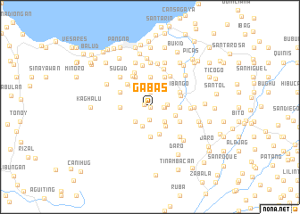
Gabas (Leyte, Philippines)Gabas is a town in the Leyte region of Philippines. An overview map of the region around Gabas is displayed below.
regional and 3d topo map of Gabas, Philippines ::
Gabas airports ::
The nearest airport is TAC - Tacloban Daniel Z Romualdez, located 34.0 km east of Gabas.
Other airports nearby include NOP - Masbate Mactan Cebu Intl (130.3 km south west), BCD - Bacolod (206.0 km west), DGT - Dumaguete (261.2 km south west), Nearby towns ::
Lutaw (0.0km north) //
Kabatuan (0.0km north) //
Lutawlutaw (0.0km north) //
Kaghalo (0.8km west) //
Kamansi (1.6km south) //
Tigbao (1.7km east) //
Sadyapun (1.8km east) //
Binibihan (1.9km north) //
Camanci (1.9km north) //
Kalangrahan (1.9km north) //
Macalpi (2.2km east) //
Tinaguban (2.6km south) //
Casilion (2.6km south east) //
Libagong (2.6km south east) //
Luinab (2.6km south west) //
Binibihan (3.0km south east) //
Mag-aso (3.3km east) //
Sogod (3.4km north west) //
Canlampay (3.6km south) //
Licod (3.6km east) //
Maulaug (3.7km south) //
Piluro (3.7km north) //
Parag-um (3.7km north) //
Bangabanga (3.6km west) //
Libas (4.0km north west) //
Tunga (4.1km east) //
Anibongon (4.1km south east) //
Abango (4.1km north east) //
Saliri (4.1km north east) //
[all distances 'as the bird flies' and approximate]  Places with similar names to Gabas, Philippines ::
Disclaimer :: Information on this page comes without warranty of any kind |
||
|
Where is Gabas? Elevation and coordinates ::
Latitude (lat): 11°14'0"N Longitude (lon): 124°43'0"E
Elevation (approx.): 120m (map arrows pan, magnifying glasses zoom) |
||
|
Visiting Gabas? Hotel/Accommodation ::
Book a hotel in Gabas Travel Guide ::
Buy a travel guide for Philippines rental cars ::
car rental offers GPS waypoint ::
download a GPX waypoint (PoI) of Gabas for your GPS receiver
|
||