|
search place name
|
||
Goa (Camarines Sur, Philippines)Goa is a town in the Camarines Sur region of Philippines. An overview map of the region around Goa is displayed below.
regional and 3d topo map of Goa, Philippines ::
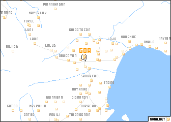
Nearby towns ::
Gimaga (1.1km west) //
Giwacloy (1.1km west) //
Cagaycay (1.1km west) //
Matacla (1.2km south) //
Halauig-gogon (1.5km north) //
San Rafael (1.7km south east) //
Catagbacan (1.7km south east) //
Tagontong (2.4km west) //
Buyo (2.6km south west) //
Calauit (2.5km east) //
Minoro (2.5km east) //
Bagacay (2.5km east) //
Mampirao (2.5km east) //
Calalahan (2.5km east) //
Tambagñan (2.5km east) //
Danlog Menor (2.5km east) //
Manzana (2.5km east) //
Telegrafo (2.5km east) //
Boclod (2.5km east) //
Tominauog (2.5km east) //
San Jose (2.9km east) //
Camagong (3.1km north east) //
Palale (3.3km north east) //
Napauon (3.4km north west) //
San Roque (3.7km north east) //
Abucayan (3.7km west) //
San Roque (3.9km north) //
San Rafael (4.4km south) //
Baliguian (4.8km north east) //
[all distances 'as the bird flies' and approximate] 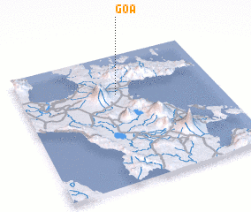 Places with similar names to Goa, Philippines ::
Disclaimer :: Information on this page comes without warranty of any kind |
||
|
Where is Goa? Elevation and coordinates ::
Latitude (lat): 13°41'49"N Longitude (lon): 123°29'36"E
Elevation (approx.): 56m (map arrows pan, magnifying glasses zoom) |
||
|
Visiting Goa? Hotel/Accommodation ::
Book a hotel in Goa Travel Guide ::
Buy a travel guide for Philippines rental cars ::
car rental offers GPS waypoint ::
download a GPX waypoint (PoI) of Goa for your GPS receiver
|
||