|
search place name
|
||
Hagdan-Bato (Rizal, Philippines)Hagdan-Bato is a town in the Rizal region of Philippines. An overview map of the region around Hagdan-Bato is displayed below.
regional and 3d topo map of Hagdan-Bato, Philippines ::

Hagdan-Bato airports ::
The nearest airport is MNL - Manila Ninoy Aquino Intl, located 8.6 km south of Hagdan-Bato.
Other airports nearby include BAG - Baguio (202.4 km north), Nearby towns ::
Santa Ana (0.7km south) //
San Pedrillo (0.7km south east) //
Namayan (1.0km south) //
Pandacan (1.0km north west) //
Kasilawan (1.3km south) //
Santa Mesa (1.7km north) //
Tanque (1.7km north) //
Zaniga (1.8km east) //
San Miguel (1.9km north west) //
San Jose (1.9km east) //
Batis (2.2km north east) //
Bel-Air Two (2.3km south) //
Santa Lucia (2.3km north east) //
Hulo (2.3km south east) //
Palanas (2.4km east) //
Mandaluyong (2.5km east) //
Tibagan (2.5km north east) //
San Juan (2.6km north) //
Welfareville (2.6km east) //
San Juan del Monte (2.7km north east) //
Balicbalic (2.8km north) //
Once (2.8km north east) //
Mapuntod (2.9km north east) //
Pinaglabanan (2.9km north east) //
Ermita (3.0km west) //
Paco (3.0km west) //
Palanan (3.2km south) //
Salapan (3.2km north east) //
Pitogo (3.2km south east) //
[all distances 'as the bird flies' and approximate] 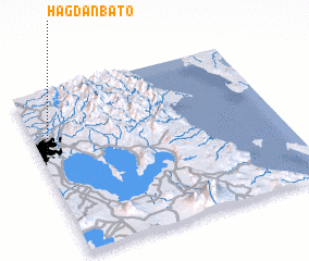 Places with similar names to Hagdan-Bato, Philippines :: Disclaimer :: Information on this page comes without warranty of any kind |
||
|
Where is Hagdan-Bato? Elevation and coordinates ::
Latitude (lat): 14°35'10"N Longitude (lon): 121°0'39"E
Elevation (approx.): 8m (map arrows pan, magnifying glasses zoom) |
||
|
Visiting Hagdan-Bato? Hotel/Accommodation ::
Book a hotel in Hagdan-Bato Travel Guide ::
Buy a travel guide for Philippines rental cars ::
car rental offers GPS waypoint ::
download a GPX waypoint (PoI) of Hagdan-Bato for your GPS receiver
|
||