|
search place name
|
||
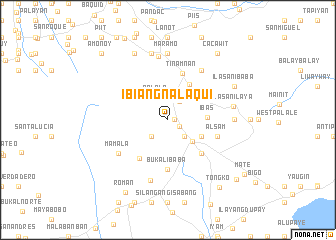
Ibiangnalaqui (Quezon, Philippines)Ibiangnalaqui is a town in the Quezon region of Philippines. An overview map of the region around Ibiangnalaqui is displayed below.
regional and 3d topo map of Ibiangnalaqui, Philippines ::
Ibiangnalaqui airports ::
The nearest airport is MNL - Manila Ninoy Aquino Intl, located 77.8 km north west of Ibiangnalaqui.
Nearby towns ::
Dapdap (0.7km east) //
Camaysa (1.5km south east) //
Manasa (2.4km north east) //
Mayowi (2.6km south east) //
Lalo (2.6km south east) //
Pook (2.6km south east) //
Domoit Canluran (2.6km south east) //
Baguio (2.6km south east) //
Malawaowa (2.6km south east) //
Palale Silañgan (2.6km south east) //
Nangca Ibaba (2.6km south east) //
Banilad (2.6km south east) //
Opias (2.6km south east) //
Catigan Silañgan (2.6km south east) //
Palale Canluran (2.6km south east) //
Catigan Canluran (2.6km south east) //
Lawigue (2.6km south east) //
Anos (2.6km south east) //
Palale Ibabang Canluran (2.6km south east) //
Domoit Silañgan (2.6km south east) //
Gibañga (2.6km south east) //
Palale Ilaya (2.6km south east) //
Nangca Ilaya (2.6km south east) //
Calantas (2.6km south east) //
Mationa (2.6km south east) //
Ipilan (2.6km south east) //
Lakawan (2.6km south east) //
Alupay (2.6km south east) //
Alitao (2.6km south west) //
[all distances 'as the bird flies' and approximate]  Places with similar names to Ibiangnalaqui, Philippines :: Disclaimer :: Information on this page comes without warranty of any kind |
||
|
Where is Ibiangnalaqui? Elevation and coordinates ::
Latitude (lat): 14°3'0"N Longitude (lon): 121°34'0"E
Elevation (approx.): 363m (map arrows pan, magnifying glasses zoom) |
||
|
Visiting Ibiangnalaqui? Hotel/Accommodation ::
Book a hotel in Ibiangnalaqui Travel Guide ::
Buy a travel guide for Philippines rental cars ::
car rental offers GPS waypoint ::
download a GPX waypoint (PoI) of Ibiangnalaqui for your GPS receiver
|
||