|
search place name
|
||
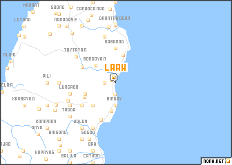
La-aw (Cebu, Philippines)La-aw is a town in the Cebu region of Philippines. An overview map of the region around La-aw is displayed below.
regional and 3d topo map of La-aw, Philippines ::
La-aw airports ::
The nearest airport is NOP - Masbate Mactan Cebu Intl, located 58.5 km south of La-aw.
Other airports nearby include TAC - Tacloban Daniel Z Romualdez (117.1 km east), BCD - Bacolod (122.6 km west), ILO - Iloilo (163.3 km west), DGT - Dumaguete (184.3 km south west), Nearby towns ::
Borbon (0.8km north west) //
Bongdo (1.8km west) //
Campusong (1.9km south) //
Bingay (3.7km south) //
Banghilig (3.7km south) //
Bongoyan (4.2km north west) //
Tagnucan (4.6km north) //
Calumboyan (4.7km south) //
Tagaytay (5.2km south west) //
Sacsac (5.2km south west) //
Lugo (5.2km west) //
Mabanog (5.6km north) //
Lubo (5.6km south west) //
Sagay (5.9km north west) //
Tabunok (6.5km south) //
Lobo (6.6km south west) //
Lungaob (7.5km west) //
Saba (7.6km north) //
Taytayan (7.6km north west) //
Kalusiya (8.2km south west) //
Tangki (8.2km south west) //
Damolog (8.3km south west) //
Mojon (8.2km west) //
Tagda (9.2km south west) //
Udlom (9.2km south west) //
Maukbokan (9.2km south west) //
Binaliw (9.2km south west) //
Ilihan (10.6km north west) //
[all distances 'as the bird flies' and approximate] 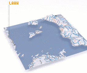 Places with similar names to La-aw, Philippines ::
Disclaimer :: Information on this page comes without warranty of any kind |
||
|
Where is La-aw? Elevation and coordinates ::
Latitude (lat): 10°50'0"N Longitude (lon): 124°2'0"E
Elevation (approx.): -32768m (map arrows pan, magnifying glasses zoom) |
||
|
Visiting La-aw? Hotel/Accommodation ::
Book a hotel in La-aw Travel Guide ::
Buy a travel guide for Philippines rental cars ::
car rental offers GPS waypoint ::
download a GPX waypoint (PoI) of La-aw for your GPS receiver
|
||