|
search place name
|
||
Labut (Abra, Philippines)Labut is a town in the Abra region of Philippines. An overview map of the region around Labut is displayed below.
regional and 3d topo map of Labut, Philippines ::

Labut airports ::
The nearest airport is BAG - Baguio, located 96.9 km south of Labut.
Nearby towns ::
Taft (1.1km south west) //
Bugui (1.3km east) //
Nalasin (2.0km west) //
San Vicente (2.2km north) //
Biqui (2.3km west) //
Oalin (2.3km west) //
Carcarabasa (2.3km west) //
Cabaroan (2.9km east) //
Lidlidda (3.3km north west) //
Banbanaal (3.8km south west) //
Lupac (4.0km south east) //
Kalumsing (4.2km north) //
Asin (4.2km north) //
Paltoc (4.2km south east) //
Banucal (4.4km north) //
Naguimba (4.6km north west) //
Sampatingan (4.8km south west) //
Elefante (4.8km west) //
Pettao (5.1km south east) //
San Vicente (5.3km south) //
Manga (5.4km south) //
McKinley (5.3km south west) //
Lintic (5.3km south west) //
Lopez (5.3km south west) //
San Jose de Bugnay (5.4km south west) //
Legaspi (5.7km south west) //
Baang (5.5km east) //
Bessang (5.9km north) //
Lancuas (5.7km east) //
[all distances 'as the bird flies' and approximate] 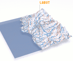 Places with similar names to Labut, Philippines ::
Disclaimer :: Information on this page comes without warranty of any kind |
||
|
Where is Labut? Elevation and coordinates ::
Latitude (lat): 17°14'50"N Longitude (lon): 120°32'18"E
Elevation (approx.): 155m (map arrows pan, magnifying glasses zoom) |
||
|
Visiting Labut? Hotel/Accommodation ::
Book a hotel in Labut Travel Guide ::
Buy a travel guide for Philippines rental cars ::
car rental offers GPS waypoint ::
download a GPX waypoint (PoI) of Labut for your GPS receiver
|
||