|
search place name
|
||
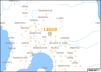
Laguio (Laguna, Philippines)Laguio is a town in the Laguna region of Philippines. An overview map of the region around Laguio is displayed below.
regional and 3d topo map of Laguio, Philippines ::
Laguio airports ::
The nearest airport is MNL - Manila Ninoy Aquino Intl, located 48.6 km west of Laguio.
Other airports nearby include BAG - Baguio (231.6 km north west), Nearby towns ::
Maypagong (0.0km north) //
San Francisco (1.8km east) //
Bagumbayan (1.8km east) //
Salangbato (1.9km north) //
Novaliches (1.9km south) //
Famy (2.5km south west) //
Pusao (2.6km south east) //
Tanawan Munti (2.6km south east) //
Bubukal (2.6km south east) //
Mayatba (2.6km south west) //
Kapatalan (2.6km south west) //
Lukong (2.6km south west) //
Siniloan (3.9km south west) //
Inaraduhan (4.1km south east) //
Polvorista (4.1km south east) //
Cabooan (4.0km north west) //
Dapi (4.0km north west) //
Talangka (4.2km north west) //
Santa Maria (4.9km north west) //
Mabitac (5.0km south west) //
Pangil (5.2km south) //
Binambang (5.2km south east) //
Nanguma (5.2km south west) //
Sulib (5.6km south) //
Labak (5.6km south) //
San Antonio (5.4km west) //
Hanayan (5.4km west) //
Maylatang (5.4km west) //
Palacio (5.8km south) //
[all distances 'as the bird flies' and approximate] 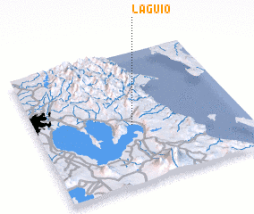 Places with similar names to Laguio, Philippines ::
Disclaimer :: Information on this page comes without warranty of any kind |
||
|
Where is Laguio? Elevation and coordinates ::
Latitude (lat): 14°27'0"N Longitude (lon): 121°28'0"E
Elevation (approx.): 20m (map arrows pan, magnifying glasses zoom) |
||
|
Visiting Laguio? Hotel/Accommodation ::
Book a hotel in Laguio Travel Guide ::
Buy a travel guide for Philippines rental cars ::
car rental offers GPS waypoint ::
download a GPX waypoint (PoI) of Laguio for your GPS receiver
|
||