|
search place name
|
||
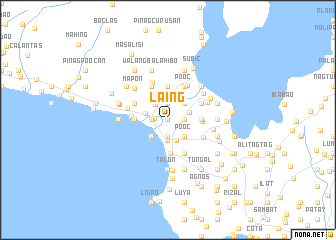
Laing (Batangas, Philippines)Laing is a town in the Batangas region of Philippines. An overview map of the region around Laing is displayed below.
regional and 3d topo map of Laing, Philippines ::
Laing airports ::
The nearest airport is MNL - Manila Ninoy Aquino Intl, located 68.3 km north of Laing.
Nearby towns ::
Palanas (0.0km north) //
Kawit (0.2km north) //
Malinis (1.5km west) //
Latag (1.8km east) //
Halang (1.8km east) //
Tolo (1.8km east) //
Pooc (1.8km east) //
Santa Tereza (1.8km east) //
Tubigan (1.8km west) //
Ipil (1.9km south) //
Santa Lucia (1.9km south) //
Balañgon (1.9km north) //
Tatlong Maria (1.9km south) //
Irucan (1.9km south) //
Pansipit (1.9km south) //
Pansol (1.9km south) //
Apacay (1.9km south) //
Ilog (1.9km south) //
Volcan (1.9km south) //
Laguili (1.9km north) //
Igoigo (1.9km north) //
Ayaoiyao (1.9km south) //
Imamao (1.9km south) //
Calayaan (1.9km south) //
Siiran (1.9km south) //
Caysasay (1.9km south) //
Cahilan (2.2km north west) //
Lemery (2.3km south) //
Taal (2.5km south) //
[all distances 'as the bird flies' and approximate]  Places with similar names to Laing, Philippines ::
Disclaimer :: Information on this page comes without warranty of any kind |
||
|
Where is Laing? Elevation and coordinates ::
Latitude (lat): 13°54'0"N Longitude (lon): 120°55'0"E
Elevation (approx.): 31m (map arrows pan, magnifying glasses zoom) |
||
|
Visiting Laing? Hotel/Accommodation ::
Book a hotel in Laing Travel Guide ::
Buy a travel guide for Philippines rental cars ::
car rental offers GPS waypoint ::
download a GPX waypoint (PoI) of Laing for your GPS receiver
|
||