|
search place name
|
||
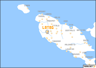
Latag (Mindoro Occidental, Philippines)Latag is a town in the Mindoro Occidental region of Philippines. An overview map of the region around Latag is displayed below.
regional and 3d topo map of Latag, Philippines ::
Latag airports ::
The nearest airport is MNL - Manila Ninoy Aquino Intl, located 124.9 km north east of Latag.
Nearby towns ::
Canlawat (0.5km north west) //
Ambolong (1.4km east) //
Hitoan (1.5km north east) //
Calamias (1.6km south) //
Mahabang Buhangin (1.7km south) //
Icatlong Parang (2.1km south east) //
Barac (2.2km north) //
Pampang (2.2km north) //
Munting Barac (2.2km north) //
Binakas (2.3km south) //
Acle (2.5km north east) //
Puucan (2.5km north east) //
Kay Cati (2.5km north east) //
Poltang Barac (3.0km north) //
Maputing Balo (3.2km east) //
Pinagdagatan (3.4km south) //
Macana (3.6km east) //
Matalo (3.8km north east) //
Maquipot (4.2km north) //
Tumibo (4.6km north west) //
Tabionan (5.2km south east) //
Lumibay (5.2km east) //
Nalimbayan (5.3km east) //
Bolboc (5.9km north) //
Tagbac (6.1km north west) //
Asabero (6.3km north) //
Tañgal (6.3km north) //
Malonglong (6.3km north) //
Maliig (6.5km north east) //
[all distances 'as the bird flies' and approximate]  Places with similar names to Latag, Philippines ::
Disclaimer :: Information on this page comes without warranty of any kind |
||
|
Where is Latag? Elevation and coordinates ::
Latitude (lat): 13°47'50"N Longitude (lon): 120°7'15"E
Elevation (approx.): 50m (map arrows pan, magnifying glasses zoom) |
||
|
Visiting Latag? Hotel/Accommodation ::
Book a hotel in Latag Travel Guide ::
Buy a travel guide for Philippines rental cars ::
car rental offers GPS waypoint ::
download a GPX waypoint (PoI) of Latag for your GPS receiver
|
||