|
search place name
|
||
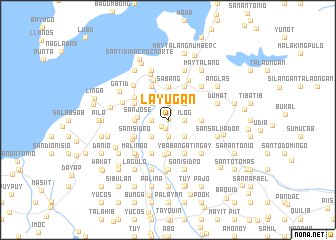
Layugan (Laguna, Philippines)Layugan is a town in the Laguna region of Philippines. An overview map of the region around Layugan is displayed below.
regional and 3d topo map of Layugan, Philippines ::
Layugan airports ::
The nearest airport is MNL - Manila Ninoy Aquino Intl, located 54.0 km north west of Layugan.
Nearby towns ::
Buboy (0.0km north east) //
Cabanbanan (0.9km north) //
Sigaras (0.9km south) //
Buenavista (1.0km south west) //
Monserrat (1.9km south) //
Salasad (1.9km south) //
Anibong (1.9km south) //
Alipit (1.8km west) //
Moosegy (1.9km north) //
Ilog (1.8km east) //
Villafranca (2.6km south west) //
Maravilla (2.6km south west) //
Corazon (2.6km south east) //
Biñang (2.6km north west) //
Lambac (2.6km north east) //
San Jose (3.4km west) //
Oogong (3.6km west) //
Tipacan (3.7km south) //
Concepcion (3.7km south) //
Magdalo (3.7km south) //
Del Vivar (3.7km south) //
Benavides (3.7km south) //
Maulawin (3.7km north) //
Sabang (3.7km north) //
Banco (3.6km east) //
Magdalena (3.9km south) //
San Isidro (4.0km south west) //
Halayhayin (4.1km south west) //
San Juan (4.0km north west) //
[all distances 'as the bird flies' and approximate]  Places with similar names to Layugan, Philippines ::
Disclaimer :: Information on this page comes without warranty of any kind |
||
|
Where is Layugan? Elevation and coordinates ::
Latitude (lat): 14°14'0"N Longitude (lon): 121°26'0"E
Elevation (approx.): 28m (map arrows pan, magnifying glasses zoom) |
||
|
Visiting Layugan? Hotel/Accommodation ::
Book a hotel in Layugan Travel Guide ::
Buy a travel guide for Philippines rental cars ::
car rental offers GPS waypoint ::
download a GPX waypoint (PoI) of Layugan for your GPS receiver
|
||