|
search place name
|
||
Libon (Northern Samar, Philippines)Libon is a town in the Northern Samar region of Philippines. An overview map of the region around Libon is displayed below.
regional and 3d topo map of Libon, Philippines ::

Libon airports ::
The nearest airport is TAC - Tacloban Daniel Z Romualdez, located 126.0 km south of Libon.
Nearby towns ::
Buquid (0.6km south) //
Sagudsoron (1.1km north) //
Giracdo (1.6km south west) //
Nahulid (1.8km east) //
Balugo (1.8km west) //
Cagbugna (2.6km north west) //
Quirhat (2.6km north west) //
Linoyahan (2.6km north west) //
Opong (2.6km north west) //
Osmeña (2.6km north west) //
Tangbo (2.6km north west) //
Sulitan (2.6km north west) //
Bongog (2.6km north west) //
Rizal (2.6km north west) //
Ribong (2.6km north west) //
Inabitinan (2.6km north west) //
Magtouad (2.6km north west) //
Lonoy (2.6km north west) //
Nago-ocan (2.6km north west) //
Giguinta (2.6km north west) //
Guibuangan (2.6km north west) //
Guyo (2.6km north west) //
Nabolo (2.6km north west) //
Hitapi-an (2.6km north west) //
Cagogobñgan (2.8km north east) //
Cagmanaba (3.0km north) //
Canoctan (3.5km north east) //
Las Navas (3.5km south west) //
Bogtosan (4.1km south west) //
[all distances 'as the bird flies' and approximate] 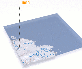 Places with similar names to Libon, Philippines ::
Disclaimer :: Information on this page comes without warranty of any kind |
||
|
Where is Libon? Elevation and coordinates ::
Latitude (lat): 12°22'0"N Longitude (lon): 125°3'0"E
Elevation (approx.): 4m (map arrows pan, magnifying glasses zoom) |
||
|
Visiting Libon? Hotel/Accommodation ::
Book a hotel in Libon Travel Guide ::
Buy a travel guide for Philippines rental cars ::
car rental offers GPS waypoint ::
download a GPX waypoint (PoI) of Libon for your GPS receiver
|
||