|
search place name
|
||
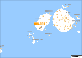
Malanta (Sulu, Philippines)Malanta is a town in the Sulu region of Philippines. An overview map of the region around Malanta is displayed below.
regional and 3d topo map of Malanta, Philippines ::
Malanta airports ::
The nearest airport is ZAM - Zamboanga Intl, located 212.6 km north east of Malanta.
Nearby towns ::
Mimul (0.4km south east) //
Silancot (1.6km west) //
Sibaud (1.9km east) //
Tubig Zina (3.7km north west) //
Pandami (4.0km north) //
Sibimbum (4.0km south west) //
Manubul (4.9km south east) //
Bukut (5.3km south west) //
Lapak (5.6km north east) //
Niug Niug (5.7km north) //
Comput (5.7km west) //
Parian Dakula (6.1km north) //
Ungas Moluha (6.1km south) //
Sibalan (6.0km east) //
Tulag (6.0km east) //
Sisangat (6.5km east) //
Calang (6.6km south west) //
Tapaan (6.8km south west) //
Siasi (7.4km north east) //
Tubig Sua (7.5km east) //
Sablay (7.6km east) //
Hambilan (7.8km north east) //
Sigangan (8.2km north east) //
Musu (8.3km east) //
Siondo (9.2km north east) //
Kurol (9.3km north east) //
Talatak (9.4km north east) //
Tulling (9.9km north east) //
Pagatpat (11.0km north east) //
[all distances 'as the bird flies' and approximate]  Places with similar names to Malanta, Philippines ::
Disclaimer :: Information on this page comes without warranty of any kind |
||
|
Where is Malanta? Elevation and coordinates ::
Latitude (lat): 5°30'10"N Longitude (lon): 120°45'50"E
Elevation (approx.): 54m (map arrows pan, magnifying glasses zoom) |
||
|
Visiting Malanta? Hotel/Accommodation ::
Book a hotel in Malanta Travel Guide ::
Buy a travel guide for Philippines rental cars ::
car rental offers GPS waypoint ::
download a GPX waypoint (PoI) of Malanta for your GPS receiver
|
||