|
search place name
|
||
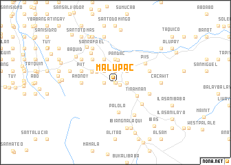
Malupac (Quezon, Philippines)Malupac is a town in the Quezon region of Philippines. An overview map of the region around Malupac is displayed below.
regional and 3d topo map of Malupac, Philippines ::
Malupac airports ::
The nearest airport is MNL - Manila Ninoy Aquino Intl, located 71.8 km north west of Malupac.
Nearby towns ::
Alilio (0.0km north) //
Ayuti (0.0km north) //
Tiawe (0.0km north) //
Cabatiti (0.0km north) //
Calañgay (0.0km north) //
Callaat (0.0km north) //
Colapi (0.0km north) //
Nagsinamo (0.0km north) //
May-it (0.0km north) //
Aliguian (0.1km south east) //
Lucban (0.8km south east) //
Abang (1.9km north) //
Bamban (1.8km west) //
Maramo (1.8km east) //
Samil (1.8km west) //
Igang (2.6km north west) //
Quilib (2.6km north east) //
Lanot (2.6km north east) //
Aliguayan (2.8km north west) //
Bitaoy (3.4km north west) //
Pandac (3.6km north) //
Mahabang Parang (3.7km north) //
Nalunao (4.1km north west) //
Tinamnan (4.1km south east) //
Gagalot (4.2km north west) //
Palola (4.9km south) //
Iyam (5.2km north west) //
Tamlong (5.4km south east) //
Taytay (5.4km west) //
[all distances 'as the bird flies' and approximate]  Places with similar names to Malupac, Philippines ::
Disclaimer :: Information on this page comes without warranty of any kind |
||
|
Where is Malupac? Elevation and coordinates ::
Latitude (lat): 14°7'0"N Longitude (lon): 121°33'0"E
Elevation (approx.): 438m (map arrows pan, magnifying glasses zoom) |
||
|
Visiting Malupac? Hotel/Accommodation ::
Book a hotel in Malupac Travel Guide ::
Buy a travel guide for Philippines rental cars ::
car rental offers GPS waypoint ::
download a GPX waypoint (PoI) of Malupac for your GPS receiver
|
||