|
search place name
|
||
Manayday (Abra, Philippines)Manayday is a town in the Abra region of Philippines. An overview map of the region around Manayday is displayed below.
regional and 3d topo map of Manayday, Philippines ::

Manayday airports ::
The nearest airport is BAG - Baguio, located 122.7 km south of Manayday.
Nearby towns ::
Dalimag (0.0km north) //
Cagutuñgan (1.9km south) //
Cabayogan (1.8km west) //
Cosocos (1.8km west) //
San Isidro (2.2km south) //
Langbaban (2.6km south west) //
Cadacad (3.5km west) //
Kimmalasag (3.7km south) //
Tangbao (3.7km south) //
Olingan (3.5km east) //
Arab (3.7km north) //
Lumaba (4.0km south east) //
Barangobong (4.0km north west) //
Tangbaw (4.1km south west) //
Ul-ulingen (4.1km south east) //
Apa-apaya (4.1km south east) //
Macray (4.0km north east) //
Maoay (4.9km east) //
Sappa-Ac (5.1km north east) //
San Marcial (5.3km east) //
Casilagan (5.6km west) //
Sagsagacat (5.6km east) //
Quermay (5.6km east) //
Cautit (5.8km north) //
Patad (5.8km south) //
Pantoc (5.8km south) //
Tablac (5.8km north) //
Malita (5.8km north) //
Palicad (5.8km south) //
[all distances 'as the bird flies' and approximate] 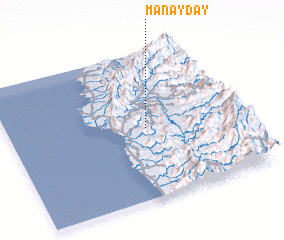 Places with similar names to Manayday, Philippines ::
Disclaimer :: Information on this page comes without warranty of any kind |
||
|
Where is Manayday? Elevation and coordinates ::
Latitude (lat): 17°29'0"N Longitude (lon): 120°36'0"E
Elevation (approx.): 184m (map arrows pan, magnifying glasses zoom) |
||
|
Visiting Manayday? Hotel/Accommodation ::
Book a hotel in Manayday Travel Guide ::
Buy a travel guide for Philippines rental cars ::
car rental offers GPS waypoint ::
download a GPX waypoint (PoI) of Manayday for your GPS receiver
|
||