|
search place name
|
||
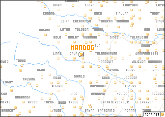
Mandog (Iloilo, Philippines)Mandog is a town in the Iloilo region of Philippines. An overview map of the region around Mandog is displayed below.
regional and 3d topo map of Mandog, Philippines ::
Mandog airports ::
The nearest airport is ILO - Iloilo, located 24.0 km south east of Mandog.
Other airports nearby include SJI - San Jose Antique (56.6 km west), BCD - Bacolod (61.3 km south east), KLO - Kalibo (86.4 km north), NOP - Masbate Mactan Cebu Intl (181.4 km east), Nearby towns ::
Pispis (0.0km north) //
Punong (0.0km north) //
Panalian (0.0km north) //
Piangdaan West (0.0km north) //
Piangdaan East (0.0km north) //
Nagba (0.0km north) //
Miapa (0.0km north) //
Pacuan (0.0km north) //
Liñagan (0.0km north) //
Lanag (0.0km north) //
Bagacay East (0.0km north) //
Caraudan (0.0km north) //
Nasuli (0.0km north) //
Inauañgan (0.0km north) //
Cabatac (0.0km north) //
Inabasan (0.0km north) //
Cabangcalan (0.0km north) //
Naslo (0.0km north) //
Bog-ot (0.0km north) //
Bacuranan (0.0km north) //
Dalusan (0.0km north) //
Bagacay West (0.0km north) //
Cananghan (0.0km north) //
Bucao (0.0km north) //
Bulay (0.0km north) //
Buntalan (0.0km north) //
Burac (0.0km north) //
Sinubsuban (0.0km north) //
Santa Rita (0.0km north) //
[all distances 'as the bird flies' and approximate]  Places with similar names to Mandog, Philippines ::
Disclaimer :: Information on this page comes without warranty of any kind |
||
|
Where is Mandog? Elevation and coordinates ::
Latitude (lat): 10°54'0"N Longitude (lon): 122°26'0"E
Elevation (approx.): 98m (map arrows pan, magnifying glasses zoom) |
||
|
Visiting Mandog? Hotel/Accommodation ::
Book a hotel in Mandog Travel Guide ::
Buy a travel guide for Philippines rental cars ::
car rental offers GPS waypoint ::
download a GPX waypoint (PoI) of Mandog for your GPS receiver
|
||