|
search place name
|
||
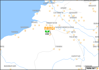
Nañgi (Maguindanao, Philippines)Nañgi is a town in the Maguindanao region of Philippines. An overview map of the region around Nañgi is displayed below.
regional and 3d topo map of Nañgi, Philippines ::
Nañgi airports ::
The nearest airport is CEB - Cebu Cotabato, located 1.9 km north west of Nañgi.
Other airports nearby include LGP - Legazpi Pagadian (112.3 km north west), CGY - Ladag Cagayan De Oro (146.6 km north), Nearby towns ::
Laguitan (0.0km north) //
Kapimpiran (0.0km north) //
Kebleg (0.0km north) //
Kenebaka (0.0km north) //
Kibatang (0.0km north) //
Kinagatan (0.0km north) //
Alangan (0.0km north) //
Manaculil-Timako (0.0km north) //
Baclayan (0.0km north) //
Bagua (0.0km north) //
Baruin (0.0km north) //
Benuren (0.0km north) //
Salpa (0.0km north) //
Buabuaya (0.0km north) //
Pimbagueran (0.0km north) //
Niyuguen (0.0km north) //
Nara (0.0km north) //
Mirab-Ridgecroft (0.0km north) //
Dorogao (0.0km north) //
Drikan (0.0km north) //
Dumbon (0.0km north) //
Gapet (0.0km north) //
Kaliawa (0.0km north) //
Midtuad (0.0km north) //
Awang (0.5km north east) //
Kalunangon (1.9km north) //
Tamontaka (3.6km north) //
Badibadi (3.7km north) //
Bubung (4.0km north) //
[all distances 'as the bird flies' and approximate]  Places with similar names to Nañgi, Philippines ::
Disclaimer :: Information on this page comes without warranty of any kind |
||
|
Where is Nañgi? Elevation and coordinates ::
Latitude (lat): 7°9'0"N Longitude (lon): 124°13'0"E
Elevation (approx.): 91m (map arrows pan, magnifying glasses zoom) |
||
|
Visiting Nañgi? Hotel/Accommodation ::
Book a hotel in Nañgi Travel Guide ::
Buy a travel guide for Philippines rental cars ::
car rental offers GPS waypoint ::
download a GPX waypoint (PoI) of Nañgi for your GPS receiver
|
||