|
search place name
|
||
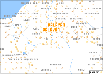
Palayan (Laguna, Philippines)Palayan is a town in the Laguna region of Philippines. An overview map of the region around Palayan is displayed below.
regional and 3d topo map of Palayan, Philippines ::
Palayan airports ::
The nearest airport is MNL - Manila Ninoy Aquino Intl, located 59.7 km north west of Palayan.
Nearby towns ::
Bangbang (0.0km north) //
Balite (0.0km north) //
Alibunbungan (0.0km north) //
Lazaan (0.0km north) //
Ilaya (0.0km north) //
Oples (0.0km north) //
Bambang (0.0km north) //
Nagcarlan (0.4km north) //
Inlolopez (0.8km north) //
Buboy (1.5km south) //
Banago (1.9km south) //
Maiton (1.9km south) //
Balinacon (1.9km south) //
San Rafael (1.9km south) //
Napapatid (1.9km south) //
Tayquin (1.8km east) //
Luquin (1.8km east) //
Culoy (1.8km east) //
San Isidro (1.8km east) //
Caytan (1.8km east) //
Dita (1.8km east) //
Ibabang Sungi (1.8km east) //
Danew (1.8km east) //
Oples (1.8km east) //
Boncol (1.8km east) //
Mojon (1.8km east) //
Yucos (1.8km west) //
Talangan (1.9km north) //
Putol (1.9km north) //
[all distances 'as the bird flies' and approximate]  Places with similar names to Palayan, Philippines ::
Disclaimer :: Information on this page comes without warranty of any kind |
||
|
Where is Palayan? Elevation and coordinates ::
Latitude (lat): 14°8'0"N Longitude (lon): 121°25'0"E
Elevation (approx.): 215m (map arrows pan, magnifying glasses zoom) |
||
|
Visiting Palayan? Hotel/Accommodation ::
Book a hotel in Palayan Travel Guide ::
Buy a travel guide for Philippines rental cars ::
car rental offers GPS waypoint ::
download a GPX waypoint (PoI) of Palayan for your GPS receiver
|
||