|
search place name
|
||
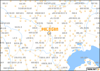
Palogan (Iloilo, Philippines)Palogan is a town in the Iloilo region of Philippines. An overview map of the region around Palogan is displayed below.
regional and 3d topo map of Palogan, Philippines ::
Palogan airports ::
The nearest airport is ILO - Iloilo, located 13.4 km south of Palogan.
Other airports nearby include BCD - Bacolod (48.2 km south east), SJI - San Jose Antique (66.0 km west), KLO - Kalibo (95.2 km north), NOP - Masbate Mactan Cebu Intl (168.6 km east), Nearby towns ::
Camambugan (0.0km north) //
Guinobatan (0.0km north) //
Tigtig (0.0km north) //
Talonghadian (0.0km north) //
Tungay (0.0km north) //
Lupa (0.0km north) //
Sangcate (0.0km north) //
Talanghauan (0.0km north) //
Sigañgao (0.0km north) //
Nasugban (0.0km north) //
Pajo (0.0km north) //
Magancina (0.0km north) //
Pongsod (0.0km north) //
Dalid (0.0km north) //
Calaboa Oeste (0.0km north) //
Conaynay (0.0km north) //
Miraga (0.0km north) //
Cagban (0.0km north) //
Manhayang (0.0km north) //
Banag (0.0km north) //
Mambuyo (0.0km north) //
Bantay (0.0km north) //
Bagombayan (0.0km north) //
Buayahon (0.0km north) //
Bololacao (0.0km north) //
Santa Barbara (1.1km south) //
Duyanduyan (1.8km west) //
San Sebastian (1.9km south) //
Cabugao Lupa (1.9km south) //
[all distances 'as the bird flies' and approximate]  Places with similar names to Palogan, Philippines ::
Disclaimer :: Information on this page comes without warranty of any kind |
||
|
Where is Palogan? Elevation and coordinates ::
Latitude (lat): 10°50'0"N Longitude (lon): 122°32'0"E
Elevation (approx.): 32m (map arrows pan, magnifying glasses zoom) |
||
|
Visiting Palogan? Hotel/Accommodation ::
Book a hotel in Palogan Travel Guide ::
Buy a travel guide for Philippines rental cars ::
car rental offers GPS waypoint ::
download a GPX waypoint (PoI) of Palogan for your GPS receiver
|
||