|
search place name
|
||
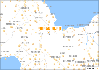
Pinagdialan (Laguna, Philippines)Pinagdialan is a town in the Laguna region of Philippines. An overview map of the region around Pinagdialan is displayed below.
regional and 3d topo map of Pinagdialan, Philippines ::
Pinagdialan airports ::
The nearest airport is MNL - Manila Ninoy Aquino Intl, located 41.0 km north west of Pinagdialan.
Nearby towns ::
Bucal (2.4km north) //
Pansol (2.6km north east) //
Tulo (3.1km west) //
Real (4.0km north west) //
Lecheria (4.1km north) //
Tadlak (4.0km north east) //
Barandal (4.0km north west) //
Bigaa (4.0km south west) //
Calamba (5.0km north) //
Santa Anastacia (5.1km south west) //
Punta (5.0km west) //
San Rafael (5.5km south west) //
Buisan (5.6km north) //
San Juan (5.6km north) //
Sabang (5.6km north) //
Sucol (5.6km north) //
San Cristobal (5.6km north) //
Bañadero (5.6km north) //
San Jose (5.6km north) //
Forestry (5.4km east) //
Parian (5.7km north) //
Lingga (5.8km north) //
Tungtungin (5.7km east) //
Lalakay (5.7km east) //
Bambang (5.7km east) //
Anos (5.7km east) //
College (5.7km east) //
San Antonio (6.0km south) //
Palo Alto (6.4km west) //
[all distances 'as the bird flies' and approximate]  Places with similar names to Pinagdialan, Philippines ::
// Pañgatlan (PH)
Disclaimer :: Information on this page comes without warranty of any kind |
||
|
Where is Pinagdialan? Elevation and coordinates ::
Latitude (lat): 14°10'0"N Longitude (lon): 121°10'0"E
Elevation (approx.): 214m (map arrows pan, magnifying glasses zoom) |
||
|
Visiting Pinagdialan? Hotel/Accommodation ::
Book a hotel in Pinagdialan Travel Guide ::
Buy a travel guide for Philippines rental cars ::
car rental offers GPS waypoint ::
download a GPX waypoint (PoI) of Pinagdialan for your GPS receiver
|
||