|
search place name
|
||
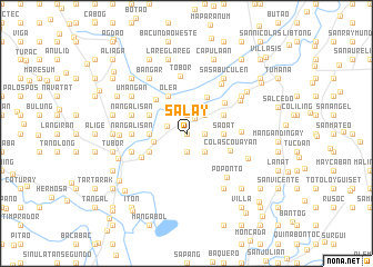
Salay (Pangasinan, Philippines)Salay is a town in the Pangasinan region of Philippines. An overview map of the region around Salay is displayed below.
regional and 3d topo map of Salay, Philippines ::
Salay airports ::
The nearest airport is BAG - Baguio, located 61.0 km north of Salay.
Other airports nearby include MNL - Manila Ninoy Aquino Intl (156.2 km south), Nearby towns ::
Buenlag (0.0km north) //
Lusilusi (0.0km north) //
Alcala (1.7km north east) //
Baong (1.8km east) //
Songiot (1.9km south) //
Gugumbaen (1.9km south) //
Canarvacanan (1.9km north) //
Palusapis (1.9km north) //
San Juan (1.9km north) //
San Vicente (2.1km west) //
Lualuan (2.6km south east) //
Caapalngan (2.6km south east) //
Namalotan (2.6km south east) //
Gualaw (2.6km south east) //
Bitulao (2.6km south east) //
San Nicolas (2.6km north east) //
Quitaquita (2.6km north east) //
San Pedro (2.6km north east) //
Bacnono (3.2km west) //
Saoat (3.6km east) //
Bugiao (3.6km east) //
Anulid (3.6km west) //
Amanperez (4.1km north east) //
Quisiquis (4.0km north east) //
Alalay (4.0km north east) //
Lope (4.0km north east) //
Nandacan (4.0km south west) //
Cacandangan (4.0km south west) //
Olituo (4.0km south west) //
[all distances 'as the bird flies' and approximate]  Places with similar names to Salay, Philippines ::
Disclaimer :: Information on this page comes without warranty of any kind |
||
|
Where is Salay? Elevation and coordinates ::
Latitude (lat): 15°50'0"N Longitude (lon): 120°31'0"E
Elevation (approx.): 22m (map arrows pan, magnifying glasses zoom) |
||
|
Visiting Salay? Hotel/Accommodation ::
Book a hotel in Salay Travel Guide ::
Buy a travel guide for Philippines rental cars ::
car rental offers GPS waypoint ::
download a GPX waypoint (PoI) of Salay for your GPS receiver
|
||