|
search place name
|
||
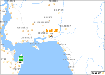
Serum (Samar, Philippines)Serum is a town in the Samar region of Philippines. An overview map of the region around Serum is displayed below.
regional and 3d topo map of Serum, Philippines ::
Serum airports ::
The nearest airport is TAC - Tacloban Daniel Z Romualdez, located 13.3 km south west of Serum.
Other airports nearby include NOP - Masbate Mactan Cebu Intl (166.5 km south west), DGT - Dumaguete (295.2 km south west), Nearby towns ::
Magallanes (1.3km west) //
Binongtoan (1.4km north west) //
Nouvilas Oriental (2.8km south east) //
Burgos (3.0km north east) //
Sugponon (3.2km west) //
Nouvilas Occidental (3.4km south west) //
New San Agustin (3.9km north west) //
San Agustin (3.9km north west) //
Basyao (5.2km south east) //
Old San Agustin (5.5km north west) //
Balahigan (5.6km north east) //
Guirang (6.3km north) //
Cabugao (6.3km south east) //
Odoc (6.5km south east) //
Salvacion (6.7km south west) //
Basey (6.7km west) //
Lolobon (7.5km south west) //
Godela (7.5km south west) //
Buena Vista (7.6km west) //
Buenavista (8.4km north west) //
Cancoral (8.5km west) //
Balayon (8.9km north) //
Legaspi (9.0km south east) //
Caoit (8.9km west) //
[all distances 'as the bird flies' and approximate]  Places with similar names to Serum, Philippines ::
Disclaimer :: Information on this page comes without warranty of any kind |
||
|
Where is Serum? Elevation and coordinates ::
Latitude (lat): 11°17'42"N Longitude (lon): 125°7'43"E
Elevation (approx.): -32768m (map arrows pan, magnifying glasses zoom) |
||
|
Visiting Serum? Hotel/Accommodation ::
Book a hotel in Serum Travel Guide ::
Buy a travel guide for Philippines rental cars ::
car rental offers GPS waypoint ::
download a GPX waypoint (PoI) of Serum for your GPS receiver
|
||