|
search place name
|
||
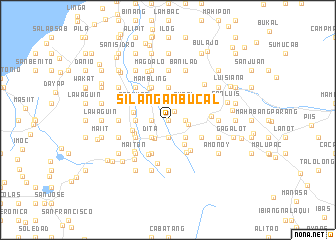
Silangan Bucal (Laguna, Philippines)Silangan Bucal is a town in the Laguna region of Philippines. An overview map of the region around Silangan Bucal is displayed below.
regional and 3d topo map of Silangan Bucal, Philippines ::
Silangan Bucal airports ::
The nearest airport is MNL - Manila Ninoy Aquino Intl, located 61.1 km north west of Silangan Bucal.
Nearby towns ::
Bayucain (0.0km north) //
Balodcod (0.0km north) //
Mataguain (0.0km north) //
Olla (1.2km north east) //
Tuy (1.9km north) //
Suba (1.9km north) //
San Roque (1.9km south) //
Munling Cawayan (1.8km east) //
Pook (1.8km east) //
Cabuyew (1.8km west) //
Talortor (1.8km east) //
Bakia (1.8km east) //
Burgos (1.8km east) //
Palayan (1.8km west) //
Panglan (1.8km east) //
Rizal (1.8km east) //
Coralao (1.8km east) //
San Isidro (1.9km north) //
Majayjay (2.2km east) //
Liliw (2.5km south west) //
Danew (2.6km south west) //
Boncol (2.6km south west) //
Oples (2.6km south west) //
Bukal (2.6km north west) //
Dita (2.6km south west) //
Caytan (2.6km south west) //
Culoy (2.6km south west) //
Burol (2.6km north east) //
Ibabang Sungi (2.6km south west) //
[all distances 'as the bird flies' and approximate]  Places with similar names to Silangan Bucal, Philippines :: Disclaimer :: Information on this page comes without warranty of any kind |
||
|
Where is Silangan Bucal? Elevation and coordinates ::
Latitude (lat): 14°9'0"N Longitude (lon): 121°27'0"E
Elevation (approx.): 225m (map arrows pan, magnifying glasses zoom) |
||
|
Visiting Silangan Bucal? Hotel/Accommodation ::
Book a hotel in Silangan Bucal Travel Guide ::
Buy a travel guide for Philippines rental cars ::
car rental offers GPS waypoint ::
download a GPX waypoint (PoI) of Silangan Bucal for your GPS receiver
|
||