|
search place name
|
||
Tinago (Bohol, Philippines)Tinago is a town in the Bohol region of Philippines. An overview map of the region around Tinago is displayed below.
regional and 3d topo map of Tinago, Philippines ::

Tinago airports ::
The nearest airport is DGT - Dumaguete, located 65.9 km south west of Tinago.
Other airports nearby include NOP - Masbate Mactan Cebu Intl (78.5 km north), BCD - Bacolod (150.7 km north west), CGY - Ladag Cagayan De Oro (157.9 km south east), ILO - Iloilo (186.1 km north west), Nearby towns ::
Tabalong (1.1km north east) //
Sunacolan (2.6km north west) //
Bingag (2.8km north west) //
Totolan (2.9km north east) //
Biking (2.9km south east) //
Majon (3.8km west) //
Catarman (4.0km east) //
Dao (4.0km south west) //
Dauis (4.1km east) //
Union (4.6km north east) //
Tagbilaran (4.7km north east) //
Canhilbus (5.1km south west) //
Tangnan (5.1km west) //
Libaong (5.4km south west) //
Santa Filomena (5.6km north west) //
San Agustin (5.6km north west) //
Mansasa (6.0km north east) //
Pooc (6.3km east) //
Guiwanon (6.3km east) //
Bool (6.3km east) //
Booy (6.3km north) //
San Vicente (6.9km east) //
Baclayon (7.2km east) //
Mormol (7.4km west) //
Taloto (7.6km north) //
Dampas (7.7km north east) //
Baliaut (7.7km east) //
Bolod (7.8km south west) //
Dao (7.8km north east) //
[all distances 'as the bird flies' and approximate] 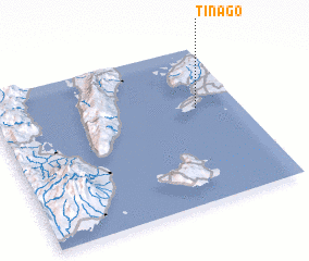 Places with similar names to Tinago, Philippines ::
Disclaimer :: Information on this page comes without warranty of any kind |
||
|
Where is Tinago? Elevation and coordinates ::
Latitude (lat): 9°36'48"N Longitude (lon): 123°49'48"E
Elevation (approx.): 45m (map arrows pan, magnifying glasses zoom) |
||
|
Visiting Tinago? Hotel/Accommodation ::
Book a hotel in Tinago Travel Guide ::
Buy a travel guide for Philippines rental cars ::
car rental offers GPS waypoint ::
download a GPX waypoint (PoI) of Tinago for your GPS receiver
|
||