|
search place name
|
||
Tiñgib (Antique, Philippines)Tiñgib is a town in the Antique region of Philippines. An overview map of the region around Tiñgib is displayed below.
regional and 3d topo map of Tiñgib, Philippines ::

Tiñgib airports ::
The nearest airport is KLO - Kalibo, located 36.3 km east of Tiñgib.
Other airports nearby include SJI - San Jose Antique (107.7 km south), ILO - Iloilo (125.2 km south east), BCD - Bacolod (154.4 km south east), NOP - Masbate Mactan Cebu Intl (263.5 km south east), Nearby towns ::
Mag-aba (1.1km north east) //
Ipil (1.9km north) //
Quiligdon (1.9km north) //
Duyong (2.3km north west) //
Jinalinan (2.6km east) //
Guia (2.8km north east) //
Tuboran (2.8km north east) //
Patria (3.5km west) //
Santo Rosario (3.6km north east) //
Bagumbayan (3.9km east) //
Canoganit Pari (4.3km north east) //
Adlusan (5.0km north west) //
Talaptap (5.4km north east) //
Dumagat (5.4km north east) //
Pandan (5.4km east) //
Nahas (5.5km west) //
Talisay (5.7km east) //
Bunga (5.7km east) //
Tubcan (6.0km north) //
Fragante (5.9km east) //
Santa Fe (5.9km east) //
Baybay (6.0km east) //
Perfecta (6.0km east) //
Buang (6.2km north east) //
Matat (6.4km north west) //
San Juan (6.4km north west) //
San Andres (6.6km south east) //
Culanos (6.8km north east) //
Botbot (7.2km south east) //
[all distances 'as the bird flies' and approximate] 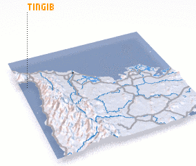 Places with similar names to Tiñgib, Philippines ::
Disclaimer :: Information on this page comes without warranty of any kind |
||
|
Where is Tiñgib? Elevation and coordinates ::
Latitude (lat): 11°43'59"N Longitude (lon): 122°2'52"E
Elevation (approx.): 3m (map arrows pan, magnifying glasses zoom) |
||
|
Visiting Tiñgib? Hotel/Accommodation ::
Book a hotel in Tiñgib Travel Guide ::
Buy a travel guide for Philippines rental cars ::
car rental offers GPS waypoint ::
download a GPX waypoint (PoI) of Tiñgib for your GPS receiver
|
||