|
search place name
|
||
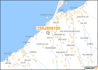
Zanja Mayor (Cavite, Philippines)Zanja Mayor is a town in the Cavite region of Philippines. An overview map of the region around Zanja Mayor is displayed below.
regional and 3d topo map of Zanja Mayor, Philippines ::
Zanja Mayor airports ::
The nearest airport is MNL - Manila Ninoy Aquino Intl, located 23.1 km north east of Zanja Mayor.
Nearby towns ::
Biwas (1.0km north) //
Santol (1.5km east) //
Punta (2.2km south) //
Bukal (2.2km north east) //
Tanza (2.3km north) //
San Juan (2.4km north east) //
Palindong (2.4km east) //
Tejero (3.0km north) //
Amaya (3.0km north west) //
Mangangbukol (3.1km east) //
General Trias (3.1km north east) //
Julugan (3.3km north) //
Sapa (4.0km north) //
Pasong Camachile (4.2km east) //
Wawa (4.4km north) //
Sampalukan (4.4km south) //
San Gabriel (4.3km east) //
Bacao (4.6km north east) //
Halayhay (4.6km west) //
Rosario (4.8km north) //
Bagbag (4.8km north) //
Salinas Station (4.8km north) //
Silangan (4.8km north) //
Kanluran (4.8km north) //
Pasongcawayan (4.9km south east) //
Calibuyo (5.0km west) //
Tres Cruces (5.2km south west) //
Muzon (5.4km north) //
Santiago (5.8km south east) //
[all distances 'as the bird flies' and approximate]  Places with similar names to Zanja Mayor, Philippines :: Disclaimer :: Information on this page comes without warranty of any kind |
||
|
Where is Zanja Mayor? Elevation and coordinates ::
Latitude (lat): 14°22'26"N Longitude (lon): 120°51'21"E
Elevation (approx.): 21m (map arrows pan, magnifying glasses zoom) |
||
|
Visiting Zanja Mayor? Hotel/Accommodation ::
Book a hotel in Zanja Mayor Travel Guide ::
Buy a travel guide for Philippines rental cars ::
car rental offers GPS waypoint ::
download a GPX waypoint (PoI) of Zanja Mayor for your GPS receiver
|
||