|
search place name
|
||
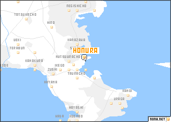
Honura (Kanagawa, Japan)Honura is a town in the Kanagawa region of Japan. An overview map of the region around Honura is displayed below.
regional and 3d topo map of Honura, Japan ::
Honura airports ::
The nearest airport is HND - Tokyo Intl, located 28.7 km north east of Honura.
Other airports nearby include OKO - Yokota Ab (55.2 km north west), OIM - Oshima (64.9 km south west), NRT - Tokyo Narita Intl (83.2 km north east), MMY - Miyake Jima Miyakejima (138.1 km south), Nearby towns ::
Hinata (1.9km south) //
Susaki (2.4km north west) //
Natsushimachō (2.4km south west) //
Oppama (2.4km west) //
Mutsuurachō (3.0km west) //
Horiguchi (4.0km north) //
Kanazawa (4.0km north) //
Funakoshi (3.5km south west) //
Taurachō (4.0km south) //
Kusugaurachō (4.0km south) //
Yokosuka (4.0km south east) //
Ikego (4.9km west) //
Zushi (6.5km south west) //
Hayama (8.2km south west) //
Hino (9.6km north west) //
[all distances 'as the bird flies' and approximate]  Places with similar names to Honura, Japan ::
Disclaimer :: Information on this page comes without warranty of any kind |
||
|
Where is Honura? Elevation and coordinates ::
Latitude (lat): 35°19'0"N Longitude (lon): 139°39'0"E
Elevation (approx.): -32768m (map arrows pan, magnifying glasses zoom) |
||
|
Visiting Honura? Hotel/Accommodation ::
Book a hotel in Honura Travel Guide ::
Buy a travel guide for Japan rental cars ::
car rental offers GPS waypoint ::
download a GPX waypoint (PoI) of Honura for your GPS receiver
|
||