|
search place name
|
||
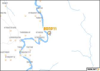
Banpyi (Myanmar)Banpyi is a town in Myanmar. An overview map of the region around Banpyi is displayed below.
regional and 3d topo map of Banpyi, Myanmar ::
Banpyi airports ::
The nearest airport is MGZ - Myeik, located 59.5 km west of Banpyi.
Other airports nearby include HHQ - Prachuap Khiri Khan Hua Hin (94.7 km north east), UTP - Rayong U Taphao Intl (206.0 km east), BKK - Bangkok Intl (238.3 km north east), Nearby towns ::
 Places with similar names to Banpyi, Myanmar ::
// Ban Na Po Yai (TH)
// Ban Pa Ye (TH)
// Ban Pi Yai (TH)
// Ban Po Yo (TH)
// Ban Puai Yai (TH)
// Ban Puai Yai (TH)
// Ban Payai (LA)
// Ban Payoua (LA)
Disclaimer :: Information on this page comes without warranty of any kind |
||
|
Where is Banpyi? Elevation and coordinates ::
Latitude (lat): 12°18'0"N Longitude (lon): 99°9'0"E
Elevation (approx.): 87m (map arrows pan, magnifying glasses zoom) |
||
|
Visiting Banpyi? Hotel/Accommodation ::
Book a hotel in Banpyi Travel Guide ::
Buy a travel guide for Myanmar rental cars ::
car rental offers GPS waypoint ::
download a GPX waypoint (PoI) of Banpyi for your GPS receiver
|
||