|
search place name
|
||
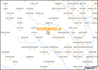
Hki-hsawngla (Kayah, Myanmar)Hki-hsawngla is a town in the Kayah region of Myanmar. An overview map of the region around Hki-hsawngla is displayed below.
regional and 3d topo map of Hki-hsawngla, Myanmar ::
Hki-hsawngla airports ::
The nearest airport is HEH - Heho, located 127.3 km north of Hki-hsawngla.
Nearby towns ::
Hpe-hso-daw (1.7km east) //
Ma-hsa-ra (1.7km east) //
Kawnla (3.7km north) //
Lè-ba-htang (4.0km north east) //
Daw Kawlö (4.0km north east) //
Longpenghku (4.0km south east) //
Kumatu Banpalan (4.0km north west) //
Rwan-ke (4.0km south west) //
Hklawpenghko (5.1km north east) //
Kyala (5.2km west) //
Kwè-hsawdaw (5.2km east) //
Hklawpang (5.8km north) //
We-ban-hku (5.8km south) //
Tilawthu (5.8km south) //
We-ban-hku (7.4km south) //
Tilawhsu (7.6km south) //
Lopu (7.6km south west) //
Lapalun (8.2km north west) //
Wān Loi-nanghpa (7.9km south east) //
Ma-hsè-la (8.2km south east) //
Me-hawng (8.9km south east) //
Lopu-hkaung-saung (8.9km south west) //
La-hya-daw (10.2km north east) //
La-kya Dawhsè (10.2km north east) //
Wān Namhu (10.2km north east) //
Lapanwe (10.2km north west) //
Ta-mö-lè (10.2km south east) //
[all distances 'as the bird flies' and approximate]  Places with similar names to Hki-hsawngla, Myanmar ::
// Casa Nagli (IT)
// Kazançlı (TR)
// Kazankol (RU)
// Kusangal (BD)
// Guessangolo (TD)
// Casangal (CO)
// Kasangala (CD)
// Kasangula (CD)
// Kasangulu (CD)
// Kasangulu (CD)
Disclaimer :: Information on this page comes without warranty of any kind |
||
|
Where is Hki-hsawngla? Elevation and coordinates ::
Latitude (lat): 19°37'0"N Longitude (lon): 97°1'0"E
Elevation (approx.): 1201m (map arrows pan, magnifying glasses zoom) |
||
|
Visiting Hki-hsawngla? Hotel/Accommodation ::
Book a hotel in Hki-hsawngla Travel Guide ::
Buy a travel guide for Myanmar rental cars ::
car rental offers GPS waypoint ::
download a GPX waypoint (PoI) of Hki-hsawngla for your GPS receiver
|
||