|
search place name
|
||
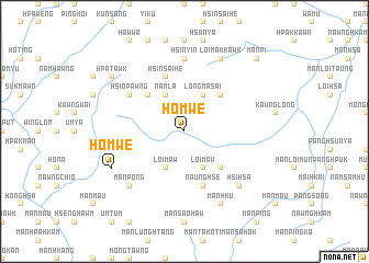
Ho-mwè (Shan, Myanmar)Ho-mwè is a town in the Shan region of Myanmar. An overview map of the region around Ho-mwè is displayed below.
regional and 3d topo map of Ho-mwè, Myanmar ::
Ho-mwè airports ::
The nearest airport is LSH - Lashio, located 103.8 km south west of Ho-mwè.
Other airports nearby include MYT - Myitkyina (190.5 km north west), Nearby towns ::
Loimaw (4.1km south east) //
Loi-maw (4.1km south west) //
Longma-sa-i (4.1km north east) //
Namla (4.1km north west) //
Tunhong (5.0km south east) //
Kyawnghkam (5.0km south east) //
Ninghsan (5.0km north east) //
Ta-kuti (5.0km north west) //
Naunghsè (5.8km south) //
Namlu (5.8km north) //
Hsinsai-he (5.8km north) //
Hsio-pawng (6.3km north west) //
Hsin-yin (7.4km north) //
Mān Pong (7.5km south west) //
Hsi-hsa (7.5km south east) //
Mān Hku (8.2km south east) //
Ho-mwè (7.7km south west) //
Loi-makkawk (8.2km north east) //
Hpa-tawk (8.8km north west) //
Mān Pi (10.0km north east) //
[all distances 'as the bird flies' and approximate] 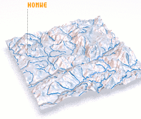 Places with similar names to Ho-mwè, Myanmar ::
Disclaimer :: Information on this page comes without warranty of any kind |
||
|
Where is Ho-mwè? Elevation and coordinates ::
Latitude (lat): 23°50'0"N Longitude (lon): 98°10'0"E
Elevation (approx.): 1482m (map arrows pan, magnifying glasses zoom) |
||
|
Visiting Ho-mwè? Hotel/Accommodation ::
Book a hotel in Ho-mwè Travel Guide ::
Buy a travel guide for Myanmar rental cars ::
car rental offers GPS waypoint ::
download a GPX waypoint (PoI) of Ho-mwè for your GPS receiver
|
||