|
search place name
|
||
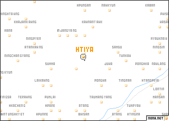
Hti-ya (Kachin State, Myanmar)Hti-ya is a town in the Kachin State region of Myanmar. An overview map of the region around Hti-ya is displayed below.
regional and 3d topo map of Hti-ya, Myanmar ::
Hti-ya airports ::
The nearest airport is MYT - Myitkyina, located 71.8 km south west of Hti-ya.
Other airports nearby include PBU - Putao (173.7 km north), Nearby towns ::
Shinkawn (1.9km north) //
Pinsau (2.5km south west) //
Maitawng (5.6km north) //
Hkumju (5.8km north) //
Juwa (5.3km east) //
Injangyang (6.5km north west) //
Pongwa (6.5km south east) //
Kawna 'Ntawk (7.6km north) //
Summa (6.9km west) //
Samdu (6.9km east) //
Ningpawnkrawn (7.5km north west) //
Pinlum (8.7km south west) //
[all distances 'as the bird flies' and approximate] 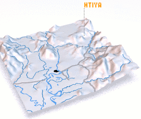 Places with similar names to Hti-ya, Myanmar ::
Disclaimer :: Information on this page comes without warranty of any kind |
||
|
Where is Hti-ya? Elevation and coordinates ::
Latitude (lat): 25°49'0"N Longitude (lon): 97°53'0"E
Elevation (approx.): 1082m (map arrows pan, magnifying glasses zoom) |
||
|
Visiting Hti-ya? Hotel/Accommodation ::
Book a hotel in Hti-ya Travel Guide ::
Buy a travel guide for Myanmar rental cars ::
car rental offers GPS waypoint ::
download a GPX waypoint (PoI) of Hti-ya for your GPS receiver
|
||