|
search place name
|
||
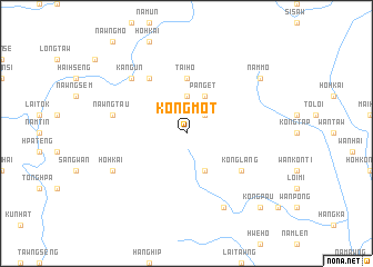
Kongmot (Shan, Myanmar)Kongmot is a town in the Shan region of Myanmar. An overview map of the region around Kongmot is displayed below.
regional and 3d topo map of Kongmot, Myanmar ::
Kongmot airports ::
The nearest airport is HEH - Heho, located 123.3 km south west of Kongmot.
Other airports nearby include MOG - Mong Hsat (160.9 km south east), KET - Kengtung (182.4 km east), LSH - Lashio (199.2 km north), MDL - Mandalay Intl (205.7 km west), Nearby towns ::
Wān Kong (2.5km north east) //
Htamngon (2.5km north east) //
Nawngkaw (3.7km north) //
Pongngo (4.1km south east) //
Pang-et (4.1km north east) //
Tai-ho (5.6km north) //
Konglang (6.4km south east) //
Ho-pong (6.4km south east) //
Wān Pong (6.5km north west) //
Nawngtau (7.2km west) //
Kang-un (7.6km north west) //
Ho-hkai (7.8km south west) //
Hangngek (8.2km south east) //
Nammo (8.9km north east) //
Kongpau (10.1km south east) //
[all distances 'as the bird flies' and approximate]  Places with similar names to Kongmot, Myanmar ::
// Kankoumadé (GN)
// Kanakamdi (PG)
// Kangaamiut (GL)
// Cana Caimito (DO)
// Kawngmu-tau (MM)
// Konkombadu (SL)
// Kungamadu (SL)
Disclaimer :: Information on this page comes without warranty of any kind |
||
|
Where is Kongmot? Elevation and coordinates ::
Latitude (lat): 21°11'0"N Longitude (lon): 97°53'0"E
Elevation (approx.): 1034m (map arrows pan, magnifying glasses zoom) |
||
|
Visiting Kongmot? Hotel/Accommodation ::
Book a hotel in Kongmot Travel Guide ::
Buy a travel guide for Myanmar rental cars ::
car rental offers GPS waypoint ::
download a GPX waypoint (PoI) of Kongmot for your GPS receiver
|
||