|
search place name
|
||
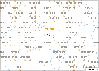
Kyu-mwē (Shan, Myanmar)Kyu-mwē is a town in the Shan region of Myanmar. An overview map of the region around Kyu-mwē is displayed below.
regional and 3d topo map of Kyu-mwē, Myanmar ::
Kyu-mwē airports ::
The nearest airport is LSH - Lashio, located 119.8 km south west of Kyu-mwē.
Other airports nearby include MYT - Myitkyina (183.8 km north west), Nearby towns ::
Namhkum (1.7km west) //
Wa-mu (2.5km south east) //
Hpakkawn (3.7km south) //
Pa-hpang (3.9km north east) //
Kawnghka (3.9km north east) //
Wingla (4.1km north west) //
Loi-lak (3.9km north west) //
Mān Se (5.0km south east) //
Namkut (5.0km north west) //
Panghkawn (5.8km north) //
Mān Kawng (5.4km east) //
Apaumka-taung (5.4km west) //
Kawngsong (5.4km west) //
Nawnghkam (6.3km south east) //
Loi-sawn (6.3km north west) //
Mān Pi (6.5km south west) //
Nahsang (6.8km east) //
Panghkawn (7.4km north) //
Mān Maü (7.0km east) //
Namkinli (7.0km east) //
Panghkawn (7.6km north) //
Hsinsai-he (7.0km west) //
Loi-lem (7.5km north west) //
Mān Hsa (7.5km south east) //
Mān Hpa (7.5km south east) //
Mān Sawk (7.7km south east) //
Panghsak (7.7km north east) //
Mān Loi-taung (8.2km south east) //
Pangkan (7.7km north west) //
[all distances 'as the bird flies' and approximate] 
Disclaimer :: Information on this page comes without warranty of any kind |
||
|
Where is Kyu-mwē? Elevation and coordinates ::
Latitude (lat): 23°57'0"N Longitude (lon): 98°16'0"E
Elevation (approx.): 1130m (map arrows pan, magnifying glasses zoom) |
||
|
Visiting Kyu-mwē? Hotel/Accommodation ::
Book a hotel in Kyu-mwē Travel Guide ::
Buy a travel guide for Myanmar rental cars ::
car rental offers GPS waypoint ::
download a GPX waypoint (PoI) of Kyu-mwē for your GPS receiver
|
||