|
search place name
|
||
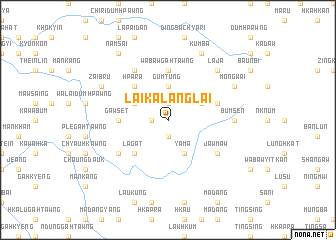
Laika-lānglai (Kachin State, Myanmar)Laika-lānglai is a town in the Kachin State region of Myanmar. An overview map of the region around Laika-lānglai is displayed below.
regional and 3d topo map of Laika-lānglai, Myanmar ::
nearby GPS traces from timatio ::
Laika-lānglai airports ::
The nearest airport is LSH - Lashio, located 132.9 km south of Laika-lānglai.
Other airports nearby include MYT - Myitkyina (138.6 km north), Nearby towns ::
Dumdu (1.9km south) //
Hpākawn (1.9km south) //
Dinghput (1.9km north) //
Daujawng (1.7km west) //
Byehtu (3.7km north) //
Gumtung (3.7km north) //
Yama (4.1km south east) //
Bumchyang (3.9km north east) //
Saiman (3.9km north west) //
Lāgat (5.0km south west) //
Hpara (5.0km north west) //
Ngagyang (5.0km north west) //
Wabaw-gahtawng (5.6km north) //
Gawset (5.1km west) //
Sama (5.4km east) //
Jawmaw (6.3km south east) //
Sumhkre (6.5km north west) //
Hkalen (6.3km south west) //
Bumsen (6.8km east) //
Lāja (7.5km north east) //
Kumba (8.1km north east) //
Zaibru (7.7km north west) //
Mong Wai (7.7km north east) //
Namsai (9.0km north west) //
[all distances 'as the bird flies' and approximate] 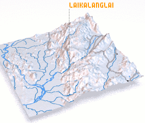 Places with similar names to Laika-lānglai, Myanmar ::
// Liikkalankylä (FI)
Disclaimer :: Information on this page comes without warranty of any kind |
||
|
Where is Laika-lānglai? Elevation and coordinates ::
Latitude (lat): 24°8'0"N Longitude (lon): 97°24'0"E
Elevation (approx.): 1061m (map arrows pan, magnifying glasses zoom) |
||
|
Visiting Laika-lānglai? Hotel/Accommodation ::
Book a hotel in Laika-lānglai Travel Guide ::
Buy a travel guide for Myanmar rental cars ::
car rental offers GPS waypoint ::
download a GPX waypoint (PoI) of Laika-lānglai for your GPS receiver
|
||