|
search place name
|
||
Lebu (Myanmar)Lebu is a town in Myanmar. An overview map of the region around Lebu is displayed below.
regional and 3d topo map of Lebu, Myanmar ::

Lebu airports ::
The nearest airport is HEH - Heho, located 203.1 km north of Lebu.
Nearby towns ::
Kanyo (1.8km east) //
Nyaungthonbin (1.8km east) //
Kinzeik (1.9km south) //
Legyawdin (2.6km north east) //
Sinzeik (2.6km south west) //
Sawbwa (2.6km south west) //
Payahnazu (2.6km south west) //
Inde (2.6km north west) //
Magyigon (2.6km north west) //
Mahin (3.7km north) //
Thayagon (3.5km west) //
Magyibinzu (4.1km south east) //
Taungoo (4.0km south east) //
Shwele-in (4.0km north east) //
Chaunggan (4.0km north east) //
Sudat (4.1km north west) //
Myaungyochaung (4.0km north west) //
Htangon (4.0km north west) //
Kyungyi (5.1km north east) //
Zibyubin (5.1km north east) //
Thapanbin (5.1km north east) //
We-gyi (5.1km south west) //
Thayetpin (5.1km north west) //
Nyaungbintha (5.3km east) //
Hnasaungbyaing (5.6km north) //
Kya-in (5.6km north) //
Mweyo (5.3km west) //
Myinsakhwet (5.3km west) //
Wedaung (5.8km south) //
[all distances 'as the bird flies' and approximate] 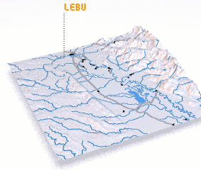 Places with similar names to Lebu, Myanmar ::
Disclaimer :: Information on this page comes without warranty of any kind |
||
|
Where is Lebu? Elevation and coordinates ::
Latitude (lat): 18°57'0"N Longitude (lon): 96°24'0"E
Elevation (approx.): 51m (map arrows pan, magnifying glasses zoom) |
||
|
Visiting Lebu? Hotel/Accommodation ::
Book a hotel in Lebu Travel Guide ::
Buy a travel guide for Myanmar rental cars ::
car rental offers GPS waypoint ::
download a GPX waypoint (PoI) of Lebu for your GPS receiver
|
||