|
search place name
|
||
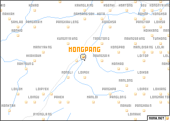
Möng Pang (Shan, Myanmar)Möng Pang is a town in the Shan region of Myanmar. An overview map of the region around Möng Pang is displayed below.
regional and 3d topo map of Möng Pang, Myanmar ::
Möng Pang airports ::
The nearest airport is LSH - Lashio, located 29.8 km south west of Möng Pang.
Other airports nearby include MDL - Mandalay Intl (259.5 km south west), KET - Kengtung (274.9 km south east), Nearby towns ::
Na-hsaw (1.7km west) //
Loi-pek (3.7km south) //
Nawngsam (3.4km east) //
Nammang (3.4km east) //
Tangtong (5.0km north east) //
Möng Li (5.0km south west) //
Kungnyawng (5.0km north west) //
Mān Mao (7.1km east) //
Kongpao (7.1km east) //
Pangkawleng (8.2km north west) //
Konghsa (9.0km north east) //
Panghpa (9.0km south east) //
Panghpat (10.1km south west) //
[all distances 'as the bird flies' and approximate]  Places with similar names to Möng Pang, Myanmar ::
// Māngpung (MM)
// Möng Ping (MM)
// Möng Pang (MM)
// Mongpong (MM)
// Mangpong (PH)
// Mangpong (PH)
// Monga-Upunga (CD)
// Muang Pang (LA)
// Muang Piang (LA)
// Mangpang (ID)
Disclaimer :: Information on this page comes without warranty of any kind |
||
|
Where is Möng Pang? Elevation and coordinates ::
Latitude (lat): 23°12'0"N Longitude (lon): 97°55'0"E
Elevation (approx.): 720m (map arrows pan, magnifying glasses zoom) |
||
|
Visiting Möng Pang? Hotel/Accommodation ::
Book a hotel in Möng Pang Travel Guide ::
Buy a travel guide for Myanmar rental cars ::
car rental offers GPS waypoint ::
download a GPX waypoint (PoI) of Möng Pang for your GPS receiver
|
||