|
search place name
|
||
Payabyu (Shan, Myanmar)Payabyu is a town in the Shan region of Myanmar. An overview map of the region around Payabyu is displayed below.
regional and 3d topo map of Payabyu, Myanmar ::

Payabyu airports ::
The nearest airport is HEH - Heho, located 20.0 km west of Payabyu.
Other airports nearby include MDL - Mandalay Intl (147.0 km north west), Nearby towns ::
Konbaw (1.7km west) //
Nyaunggon (1.9km north) //
Peinnebu (1.9km south) //
Mong Ta-wa (1.7km east) //
Sinhe (2.5km north west) //
Nanhu (2.5km south west) //
Kyaungna (2.5km north east) //
Shwenyaung (3.5km west) //
Konlin (3.5km west) //
Konmon (3.9km north west) //
Meng Kong (3.9km north east) //
Peinnegon (3.9km north east) //
Kangaung (5.1km south west) //
Thitpintaung (5.1km north east) //
Wabya (5.2km east) //
Pun-nge (5.6km north) //
Konmo (5.6km north) //
Chaungdaw (5.5km west) //
Taunggyi (5.5km east) //
Sakangyi (5.5km west) //
Tayaw (5.5km west) //
Sawsi (5.5km east) //
Ye-nwe (6.6km south west) //
Heke (6.6km north west) //
Bawbin (6.4km north east) //
Myothit (6.4km north east) //
Chaunggwe (6.4km north west) //
Ganaingshe (6.6km north east) //
Konnyu (7.4km north) //
[all distances 'as the bird flies' and approximate] 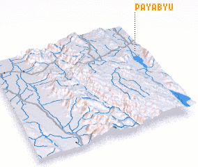 Places with similar names to Payabyu, Myanmar ::
Disclaimer :: Information on this page comes without warranty of any kind |
||
|
Where is Payabyu? Elevation and coordinates ::
Latitude (lat): 20°46'0"N Longitude (lon): 96°59'0"E
Elevation (approx.): 1009m (map arrows pan, magnifying glasses zoom) |
||
|
Visiting Payabyu? Hotel/Accommodation ::
Book a hotel in Payabyu Travel Guide ::
Buy a travel guide for Myanmar rental cars ::
car rental offers GPS waypoint ::
download a GPX waypoint (PoI) of Payabyu for your GPS receiver
|
||