|
search place name
|
||
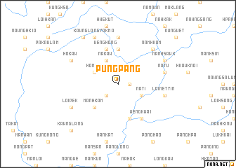
Pungpang (Shan, Myanmar)Pungpang is a town in the Shan region of Myanmar. An overview map of the region around Pungpang is displayed below.
regional and 3d topo map of Pungpang, Myanmar ::
Pungpang airports ::
The nearest airport is LSH - Lashio, located 61.1 km north west of Pungpang.
Other airports nearby include KET - Kengtung (207.9 km south east), HEH - Heho (255.6 km south west), Nearby towns ::
Kunglom (1.7km east) //
Na-möng (2.5km south west) //
Na-ti (3.9km south east) //
Na-kaw (4.1km north west) //
Ho-mun (3.9km north west) //
Mān Hkam (5.0km south west) //
Mān Se-le (5.6km north) //
Nawngngu (5.8km south) //
Wenghong (5.8km north) //
Weng Kwai (6.5km south east) //
Ho-nam (7.4km north) //
Loi-metyin (7.1km east) //
Na-tu (7.1km east) //
Namhkam (7.6km north east) //
Namhsawk (7.8km north east) //
Loi-pek (7.8km south west) //
Ho-kaw (7.8km north west) //
Kawnglangyokma (8.2km north west) //
Möng Tawm (9.0km north west) //
Kawnglang (10.1km south west) //
[all distances 'as the bird flies' and approximate]  Places with similar names to Pungpang, Myanmar ::
// Pāngping (MM)
// Pāngpong (MM)
// Pangpeng (MM)
// Pāngpeng (MM)
// Pawngping (MM)
// Pang-Pang (BJ)
// Pingo Pingo (CF)
// Poungou-Poungou (CG)
// Ponga Ponga (ZM)
// Pango Pango (MZ)
Disclaimer :: Information on this page comes without warranty of any kind |
||
|
Where is Pungpang? Elevation and coordinates ::
Latitude (lat): 22°38'0"N Longitude (lon): 98°13'0"E
Elevation (approx.): 942m (map arrows pan, magnifying glasses zoom) |
||
|
Visiting Pungpang? Hotel/Accommodation ::
Book a hotel in Pungpang Travel Guide ::
Buy a travel guide for Myanmar rental cars ::
car rental offers GPS waypoint ::
download a GPX waypoint (PoI) of Pungpang for your GPS receiver
|
||