|
search place name
|
||
Sabata (Rakhine, Myanmar)Sabata is a town in the Rakhine region of Myanmar. An overview map of the region around Sabata is displayed below.
regional and 3d topo map of Sabata, Myanmar ::

Sabata airports ::
The nearest airport is KYP - Kyaukpyu, located 16.4 km north west of Sabata.
Other airports nearby include SNW - Thandwe (117.5 km south east), AKY - Sittwe (120.8 km north west), Nearby towns ::
Mawgyi (1.7km east) //
Ma-u-daw (1.9km north) //
Krawngdin (1.9km north) //
Lahe (1.7km west) //
Migyaungyethauk (2.5km north east) //
Thechwein (2.5km north west) //
Sinbôk (2.5km south west) //
Wadaw (4.1km north east) //
Kyettein (4.0km south east) //
Taungmaw (5.1km north west) //
Pachwin (5.2km west) //
Ngalonzu (5.6km south) //
Thitpôktaung (5.8km south) //
Kyaukse (5.8km south) //
Kalaba (5.8km north) //
Chaungmyaw (6.4km south west) //
Wadaung (6.4km south east) //
Thapanchaung (6.6km south west) //
Dodaung (7.4km south) //
Kranchaing (7.4km north) //
Awadaung (7.4km south) //
Thinchaung (7.2km west) //
Zinchaung (7.2km west) //
Semaw (7.6km north) //
Kyauktan (7.6km north east) //
Ma-ubyein (7.9km south east) //
Indaunggyi (8.2km south west) //
Kyaukpyauk (9.1km south west) //
Pyanchaung (9.1km north east) //
[all distances 'as the bird flies' and approximate] 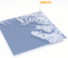 Places with similar names to Sabata, Myanmar ::
Disclaimer :: Information on this page comes without warranty of any kind |
||
|
Where is Sabata? Elevation and coordinates ::
Latitude (lat): 19°18'0"N Longitude (lon): 93°37'0"E
(map arrows pan, magnifying glasses zoom) |
||
|
Visiting Sabata? Hotel/Accommodation ::
Book a hotel in Sabata Travel Guide ::
Buy a travel guide for Myanmar rental cars ::
car rental offers GPS waypoint ::
download a GPX waypoint (PoI) of Sabata for your GPS receiver
|
||