|
search place name
|
||
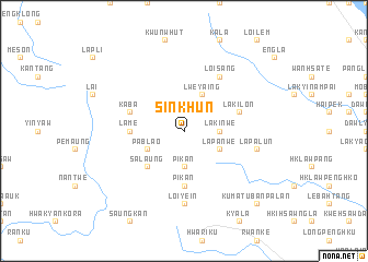
Sinkhun (Shan, Myanmar)Sinkhun is a town in the Shan region of Myanmar. An overview map of the region around Sinkhun is displayed below.
regional and 3d topo map of Sinkhun, Myanmar ::
Sinkhun airports ::
The nearest airport is HEH - Heho, located 116.6 km north of Sinkhun.
Nearby towns ::
Pikan (3.7km south) //
Lakinwe (3.5km east) //
Lweyaing (4.1km north east) //
Lapanwe (4.0km south east) //
Pablao (4.0km south west) //
Salaung (5.1km south west) //
Lame (5.2km west) //
Pikan (5.6km south) //
Kaba (5.6km west) //
Lakilon (5.6km east) //
Loi-sang (6.6km north east) //
Loi-yein (7.4km south) //
Lapalun (7.2km east) //
Kumatu Banpalan (10.2km south east) //
[all distances 'as the bird flies' and approximate]  Places with similar names to Sinkhun, Myanmar ::
// Sannikhin (MM)
// Si Nakhon (TH)
// Singgahan (ID)
// Sona Khān (PK)
// Sona Khān (PK)
// Sona Khān (PK)
// Sono Khān (PK)
// Sèn Khoun (LA)
// Xuan Khánh (VN)
// Xuân Khánh (VN)
Disclaimer :: Information on this page comes without warranty of any kind |
||
|
Where is Sinkhun? Elevation and coordinates ::
Latitude (lat): 19°42'0"N Longitude (lon): 96°55'0"E
Elevation (approx.): 1409m (map arrows pan, magnifying glasses zoom) |
||
|
Visiting Sinkhun? Hotel/Accommodation ::
Book a hotel in Sinkhun Travel Guide ::
Buy a travel guide for Myanmar rental cars ::
car rental offers GPS waypoint ::
download a GPX waypoint (PoI) of Sinkhun for your GPS receiver
|
||