|
search place name
|
||
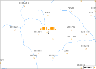
Sintlang (Chin, Myanmar)Sintlang is a town in the Chin region of Myanmar. An overview map of the region around Sintlang is displayed below.
regional and 3d topo map of Sintlang, Myanmar ::
Sintlang airports ::
The nearest airport is AJL - Aizwal Aizawl, located 171.7 km north west of Sintlang.
Other airports nearby include CGP - Chittagong Shah Amanat Intl (188.2 km west), CXB - Cox's Bazar Coxs Bazar (201.9 km south west), IXH - Kailashahar (268.9 km north west), Nearby towns ::
 Places with similar names to Sintlang, Myanmar ::
// Seindling (AT)
// Sendling (DE)
// Sentlang (IN)
// Santa Elena 2 (MX)
// Sindialong (SN)
// Saint-Launeuc (FR)
// Sindulang (ID)
// Sandaoliang (CN)
// Sandaoling (CN)
// Sandaoling (CN)
Disclaimer :: Information on this page comes without warranty of any kind |
||
|
Where is Sintlang? Elevation and coordinates ::
Latitude (lat): 22°24'0"N Longitude (lon): 93°38'0"E
Elevation (approx.): 1166m (map arrows pan, magnifying glasses zoom) |
||
|
Visiting Sintlang? Hotel/Accommodation ::
Book a hotel in Sintlang Travel Guide ::
Buy a travel guide for Myanmar rental cars ::
car rental offers GPS waypoint ::
download a GPX waypoint (PoI) of Sintlang for your GPS receiver
|
||