|
search place name
|
||
Thale-kyin (Mandalay, Myanmar)Thale-kyin is a town in the Mandalay region of Myanmar. An overview map of the region around Thale-kyin is displayed below.
regional and 3d topo map of Thale-kyin, Myanmar ::

Thale-kyin airports ::
The nearest airport is MDL - Mandalay Intl, located 57.4 km south west of Thale-kyin.
Other airports nearby include HEH - Heho (133.4 km south), LSH - Lashio (175.7 km north east), Nearby towns ::
Pet-sut-te (2.5km north west) //
Kontha (3.7km north) //
Pa-kan (4.1km north west) //
Nyaungni (5.1km north west) //
Baw (5.5km east) //
Pongon (5.5km east) //
Ingyi (6.4km north west) //
Inson (6.5km north east) //
Pathin (6.5km north east) //
Pawpyin (6.9km east) //
Nyanyintha (7.1km west) //
Kangyigon (7.8km north west) //
Thabyegyin (7.8km south west) //
Tha-youk-myaung (7.8km south west) //
Thike-taw (7.8km south east) //
Sin-gyaung (8.8km north west) //
Anisakan (8.8km north west) //
Zegon (8.8km north west) //
Inya (10.1km north east) //
[all distances 'as the bird flies' and approximate] 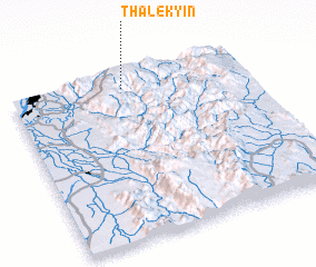 Places with similar names to Thale-kyin, Myanmar :: Disclaimer :: Information on this page comes without warranty of any kind |
||
|
Where is Thale-kyin? Elevation and coordinates ::
Latitude (lat): 21°55'0"N Longitude (lon): 96°29'0"E
Elevation (approx.): 1067m (map arrows pan, magnifying glasses zoom) |
||
|
Visiting Thale-kyin? Hotel/Accommodation ::
Book a hotel in Thale-kyin Travel Guide ::
Buy a travel guide for Myanmar rental cars ::
car rental offers GPS waypoint ::
download a GPX waypoint (PoI) of Thale-kyin for your GPS receiver
|
||