|
search place name
|
||
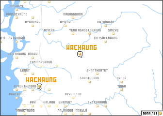
Wachaung (Myanmar)Wachaung is a town in Myanmar. An overview map of the region around Wachaung is displayed below.
regional and 3d topo map of Wachaung, Myanmar ::
Wachaung airports ::
The nearest airport is MGZ - Myeik, located 77.4 km south of Wachaung.
Other airports nearby include HHQ - Prachuap Khiri Khan Hua Hin (144.9 km east), BKK - Bangkok Intl (222.0 km north east), Nearby towns ::
Tilu (2.6km north east) //
Shanthe Atet (5.2km south east) //
Ngadetchaung (5.8km north) //
Shanthe Auk (5.8km south) //
Taminmasa Atet (5.7km west) //
Yebu (5.8km north) //
Thitswechaung (6.6km north east) //
Pyicha (8.2km north west) //
Sinzwe (9.1km north east) //
Kataungni (9.2km north east) //
Pyicha (9.1km north west) //
Kyaukthinbawpya (10.3km south west) //
[all distances 'as the bird flies' and approximate]  Places with similar names to Wachaung, Myanmar ::
// Woching (DE)
// Washunga (US)
// Hwach'ang (KP)
// Weiching (DE)
// Wai-ch'eng (TW)
// Wai-chung (TW)
// Wai-shuang (TW)
// Wu-ch'eng (TW)
// Wu-ch'eng (TW)
// Wei-chuang (TW)
Disclaimer :: Information on this page comes without warranty of any kind |
||
|
Where is Wachaung? Elevation and coordinates ::
Latitude (lat): 13°8'0"N Longitude (lon): 98°43'0"E
Elevation (approx.): 76m (map arrows pan, magnifying glasses zoom) |
||
|
Visiting Wachaung? Hotel/Accommodation ::
Book a hotel in Wachaung Travel Guide ::
Buy a travel guide for Myanmar rental cars ::
car rental offers GPS waypoint ::
download a GPX waypoint (PoI) of Wachaung for your GPS receiver
|
||