|
search place name
|
||
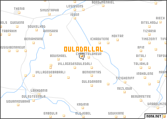
Oulad ʼAllal (Algeria)Oulad ʼAllal is a town in Algeria. An overview map of the region around Oulad ʼAllal is displayed below.
regional and 3d topo map of Oulad ʼAllal, Algeria ::
Oulad ʼAllal airports ::
The nearest airport is ALG - Algier Houari Boumediene, located 42.3 km west of Oulad ʼAllal.
Other airports nearby include BJA - Bejaja Soummam (124.3 km east), Nearby towns ::
Chabet el Ameur (1.0km north east) //
Village des Ouled Ali (2.4km south west) //
Ouled Sidi Saad (2.4km south east) //
Beni Enntas (4.0km south) //
Ichaoutene (4.8km north east) //
Ouled Ben Doukrane (5.0km south west) //
Bou Ismael (4.5km west) //
Ouled Amara (6.1km south) //
Ouled Abd Allah (5.8km north east) //
Ouled Ben Mechk (6.0km west) //
Tala Madi (6.2km west) //
Village Ben Tezerhrit (7.1km south east) //
Village de Baba Ali (7.0km south west) //
Moktar (7.6km north east) //
ʼAïn NʼSara (8.1km north west) //
[all distances 'as the bird flies' and approximate]  Places with similar names to Oulad ʼAllal, Algeria ::
// Oulad Allal (MA)
// Oulad Allal (MA)
// Ouled Allal (MA)
// Oltulili (KE)
// Oulad Allal (MA)
// Oulad Ouilal (MA)
// Oulad ʼAllal (MA)
// Oulad el Alia (MA)
// Oulad Allal (DZ)
// Oulad Allal (DZ)
Disclaimer :: Information on this page comes without warranty of any kind |
||
|
Where is Oulad ʼAllal? Elevation and coordinates ::
Latitude (lat): 36°38'0"N Longitude (lon): 3°41'0"E
Elevation (approx.): 292m (map arrows pan, magnifying glasses zoom) |
||
|
Visiting Oulad ʼAllal? Hotel/Accommodation ::
Book a hotel in Oulad ʼAllal Travel Guide ::
Buy a travel guide for Algeria rental cars ::
car rental offers GPS waypoint ::
download a GPX waypoint (PoI) of Oulad ʼAllal for your GPS receiver
|
||