|
search place name
|
||
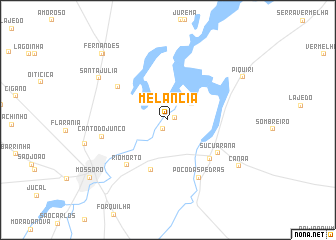
Melancia (Rio Grande do Norte, Brazil)Melancia is a town in the Rio Grande do Norte region of Brazil. An overview map of the region around Melancia is displayed below.
regional and 3d topo map of Melancia, Brazil ::
Melancia airports ::
The nearest airport is FOR - Fortaleza Pinto Martins Intl, located 205.6 km north west of Melancia.
Nearby towns ::
Umari (0.8km east) //
Passagem de Pedra (1.2km south west) //
Jurema Sêca (3.2km north east) //
Rincão (5.9km south) //
Canto Serrote (6.4km south east) //
Carnaúba Verde (6.7km north west) //
Suçuarana (6.7km south east) //
Rio Morto (6.8km south west) //
Poço das Pedras (7.3km south east) //
Canto do Junco (7.6km west) //
Santa Júlia (9.0km north west) //
Canaã (9.5km south east) //
Piquiri (9.6km north east) //
Sítio Lagoa de Cima (10.3km north west) //
Fernandes (10.5km north west) //
Mossoró (10.8km south west) //
[all distances 'as the bird flies' and approximate]  Places with similar names to Melancia, Brazil ::
// Melan-ashe (MM)
// Mala Noche (CU)
// Mala Noche (CU)
// Milencha (BG)
// Malynychi (UA)
// Malancha (BD)
// Mālancha (BD)
// Mālancha (BD)
// Mālancha (BD)
// Mālancha (BD)
Disclaimer :: Information on this page comes without warranty of any kind |
||
|
Where is Melancia? Elevation and coordinates ::
Latitude (lat): 5°8'0"S Longitude (lon): 37°16'0"W
Elevation (approx.): 9m (map arrows pan, magnifying glasses zoom) |
||
|
Visiting Melancia? Hotel/Accommodation ::
Book a hotel in Melancia Travel Guide ::
Buy a travel guide for Brazil rental cars ::
car rental offers GPS waypoint ::
download a GPX waypoint (PoI) of Melancia for your GPS receiver
|
||