|
search place name
|
||
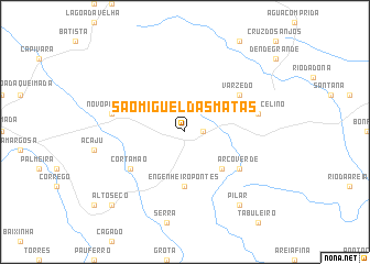
São Miguel das Matas (Bahia, Brazil)São Miguel das Matas is a town in the Bahia region of Brazil. An overview map of the region around São Miguel das Matas is displayed below.
regional and 3d topo map of São Miguel das Matas, Brazil ::
São Miguel das Matas airports ::
The nearest airport is SSA - Salvador Deputado Luis Eduardo Magalhaes, located 122.0 km east of São Miguel das Matas.
Other airports nearby include IOS - Ilheus (204.1 km south), Nearby towns ::
Barro (1.8km east) //
Seixa (5.2km south east) //
Engenheiro Pontes (5.6km south) //
Corta Mão (6.6km south west) //
Arco Verde (6.6km south east) //
Varzedo (6.6km north east) //
Novo Paraíso (7.5km west) //
José Marcelino (7.5km east) //
Pilar (9.2km south east) //
Alto Sêco (10.3km south west) //
Venda Nova (10.3km south west) //
[all distances 'as the bird flies' and approximate]  Places with similar names to São Miguel das Matas, Brazil :: Disclaimer :: Information on this page comes without warranty of any kind |
||
|
Where is São Miguel das Matas? Elevation and coordinates ::
Latitude (lat): 13°1'0"S Longitude (lon): 39°27'0"W
Elevation (approx.): 374m (map arrows pan, magnifying glasses zoom) |
||
|
Visiting São Miguel das Matas? Hotel/Accommodation ::
Book a hotel in São Miguel das Matas Travel Guide ::
Buy a travel guide for Brazil rental cars ::
car rental offers GPS waypoint ::
download a GPX waypoint (PoI) of São Miguel das Matas for your GPS receiver
|
||